Interesting Stuff!: 8-Mile Loop Hike on NE Side of Mt. Chocorua (20-Jul-2010)

vftt.org

Help Support vftt.org:

This site may earn a commission from merchant affiliate links, including eBay, Amazon, and others.

1HappyHiker

Well-known member
Joined
Jan 18, 2007
Messages
1,973
Reaction score
405
Location
Bethlehem, NH
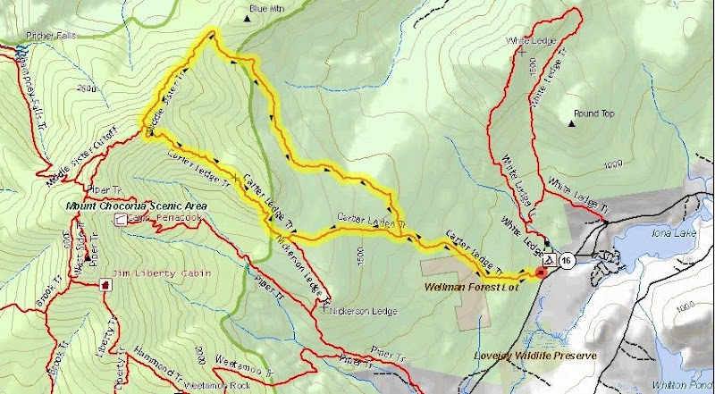
There were a lot of things I found interesting while hiking a loop that I'd never done before. My route is shown on the map below.
It involved going up the Carter Ledge Trail and returning via the Middle Sister Trail.

Map.jpg

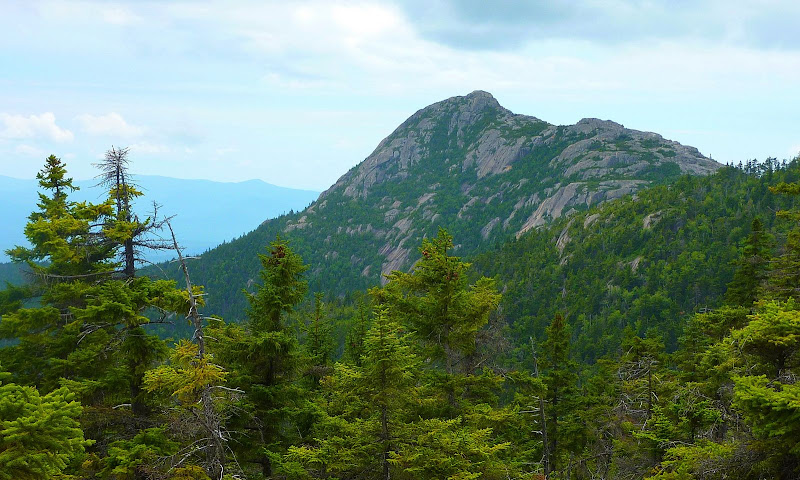
First of all, I think it's interesting that a trail named the Carter Ledge Trail isn't located in the Carter Range!:D But that aside, I thought the vistas available from this loop-hike were both interesting and varied. Of course, Mt. Chocorua is the dominant feature that's visible on the upper portion of the Carter Ledge Trail. The overcast conditions on this particular day resulted in a less than ideal images, not only for the Chocorua photo, but also for other photos in this Trip Report. But hey! At least I didn't get rained on!:)

Although the views of Chocorua were quite impressive from the Carter Ledge Trail, the snapshot shown below is the best I could get on this particular day.

P1060251.JPG

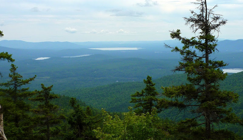
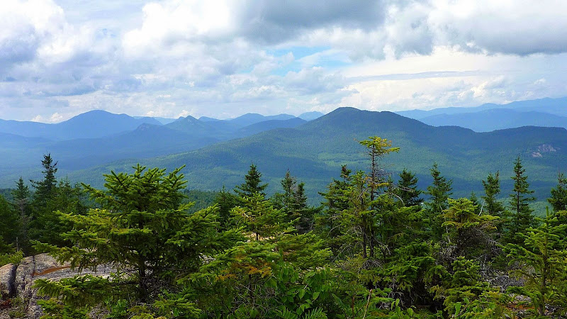
Besides the view of Chocorua, which I think is always interesting from any vantage point, this loop also provides other vistas that are interesting. However, I've only posted 2 snapshots of other landscape scenes (shown below). With the intermittent overcast conditions, I was able to capture just a few semi-decent images.

View from Carter Ledge Overlooking Lakes & Ponds East of the Conway Area

P1060213.JPG

View from Upper Part of Middle Sister Trail (Carrigain Notch Area on Left; Bear Mtn on Right)

NorthWestVu.JPG

In addition to distant vistas, there were other things which were much closer at-hand, and I found them to be just as interesting.
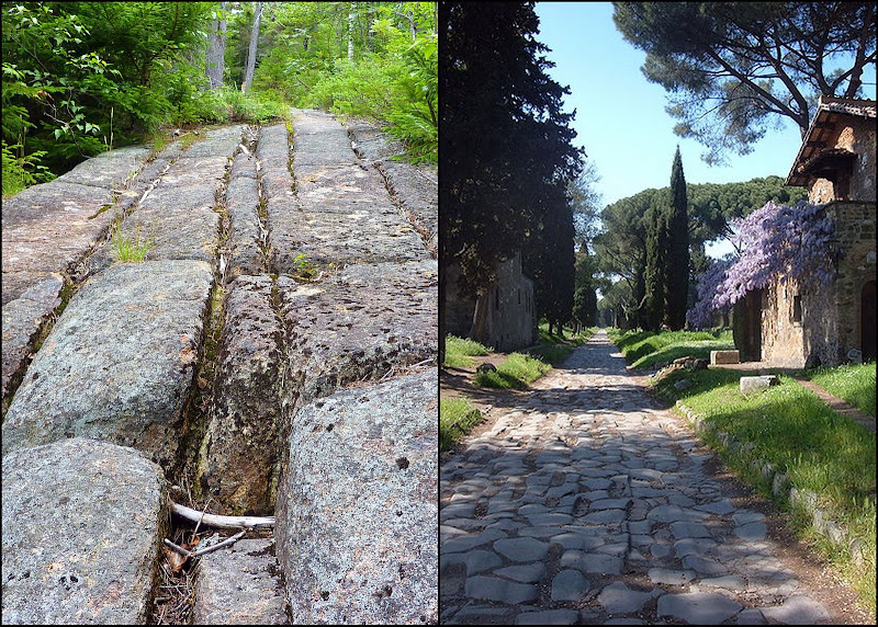
For example, take a look at the photo below which shows a segment of treadway on the Carter Ledge Trail. I've never personally seen the ancient roadway in Italy that's named the Appian Way, but I have seen photos of it. Although there are obvious differences, nonetheless, the side-by-side photos (shown below) do contain some similarities! Mother Nature is quite a stone mason!

VFTT1.jpg

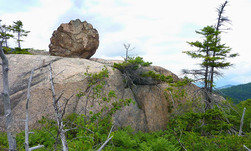
Another item that interested me was the boulder shown in the snapshot below. Rather than having the smooth & rounded profile of most boulders in locations such as this, this boulder has a jagged & irregular profile which is sort of like boulders seen at the high elevations in the Presidential Range. It almost looks like I did a poor job of photoshopping a boulder into the scene.:eek: But nope! It is what it is.
The boulder looks the same in real-life as it does in the photo!

P1060236.JPG

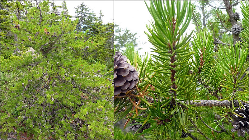
I've read in the WMG that Carter Ledge has one of the few colonies of Jack Pine that exist in the White Mountains. (It's my understanding that the major portion of the Jack Pine range is in Canada.) I'm still a neophyte at identifying plants, but I think that the composite photo below shows a Jack Pine that I saw on Carter Ledge. PLEASE, someone correct me if this is NOT a Jack Pine!

VFTT2.jpg

Overall, this was a very enjoyable hike. If I had to say anything negative, it would be that I found the lower portion of the Middle Sister Trail to be the least interesting portion of this loop. Oh! And for anyone unfamiliar with the Carter Ledge Trail, on the upper portions, there are some ledges that slope steeply downward which could be dangerous in wet (or icy) conditions.

1HappyHiker
 
Last edited:
As a long-time lover of Chocorua, I enjoyed your account, especially since the only section of your route that I have hiked is the upper half of Carter Ledge Trail, from where the Nickerson Ledge Tr. joins it. I particularly liked your side-by-side with the Appian Way - imaginative! As to those rare jack pines, your photos look like what I took to be them, the two times that I saw them, but I too am no dendrologist.

Isn't the White Ledge campground closed? Where did you park?
Hmmm! Mike, I'm wondering if maybe you are thinking of some other campground?:confused:
The White Ledge Campground was open on the day I was there, and folks were camping (albeit, not very many). The campground is still listed on the Forest Service website (click HERE for link).

Further regarding the photos of the trees that I posted, I could be mistaken, but I'd guess that there are probably only a very limited number of Jack Pine enthusiasts.:D Nonetheless, for anyone who is interested, I did receive a PM from a USFS retiree (David Govatski) who confirmed that the photos I posted do indeed show the Jack Pine. He also provided the following information.

"Jack pine is normally considered to have a serotinous cone that takes 160 degrees of heat to open and drop the seeds. But many of our (New Hampshire) jack pine are non-serotinous. They have adapted to our relatively long duration forest fire cycles and open on their own on hot days. The cones are very persistent and you can see many years of cones on trees. The tree is really a cold climate Canadian species with some outliers in northern New England. There are around 8-10 locations in NH for jack pine, and many in Maine, and a few in the Adirondacks."
 
Hmmm! Mike, I'm wondering if maybe you are thinking of some other campground?:confused:
The White Ledge Campground was open on the day I was there, and folks were camping (albeit, not very many).

No, White Ledge was the one I meant. Friends of mine who have camped there with a large group one weekend every summer for years were told some time ago that White Ledge would be closed this July because of logging operations. Either they were misinformed or there has been a change of plans.

As to the jack pines of NH, I haven't searched for it, but there was a thread on that here several years ago. I think at that time there were thought to be only 3 or 4 locations, including Carter Ledge, and people tried to identify the others.
 
Hmmm! Mike, I'm wondering if maybe you are thinking of some other campground?:confused:
The White Ledge Campground was open on the day I was there, and folks were camping (albeit, not very many). The campground is still listed on the Forest Service website (click HERE for link).
No, White Ledge was the one I meant. Friends of mine who have camped there with a large group one weekend every summer for years were told some time ago that White Ledge would be closed this July because of logging operations. Either they were misinformed or there has been a change of plans.

Hey Mike . . . first of all, I want to thank you for your nice words in your initial reply to my Trip Report. I neglected to do that in my previous response. Sorry 'bout that!

Regarding the situation at White Ledge Campground, perhaps there is something going on there to keep people away. As I indicated earlier, I did see a few folks camping. HOWEVER, it did seem odd to me that there were so many vacant campsites during the peak summer camping season. I'm purely speculating, but maybe a lot of folks (like your friends) read or were told something about the campground being closed. That might account for why there were so few campers.

Hopefully, someone on this Forum will have some info that will clarify this.
 
I gather, from this WMNF 5-year plan, dated March 27, 2008, that White Ledge Campground is to be "decommissioned," although I can't tell when. At p. 31, it says that the plan for White Ledge is:

Decommission campground. Retain one toilet
building for trailhead use; improve trailhead
parking (Carter Ledge); install 4-6 volunteersites
with hookups. The actions at this site are
beyond the 5 year scope of this program of work
unless additional funding from the Capital
Improvement Program or other sources can be
obtained.
 
I gather, from this WMNF 5-year plan, dated March 27, 2008, that White Ledge Campground is to be "decommissioned," although I can't tell when.
Great detective work, Mike!

White Ledge Campground looks like a really nice place. It would be a shame if it were decommissioned. It's so conveniently located for folks who want to set up a base camp for sightseeing & hiking in the Chocorua area, and North Conway area, and even for hiking the complex of trails originating in the Wonalancet area.
 
Regarding the situation at White Ledge Campground, perhaps there is something going on there to keep people away. As I indicated earlier, I did see a few folks camping. HOWEVER, it did seem odd to me that there were so many vacant campsites during the peak summer camping season. I'm purely speculating, but maybe a lot of folks (like your friends) read or were told something about the campground being closed. That might account for why there were so few campers.

Hopefully, someone on this Forum will have some info that will clarify this.

This is by no means official, and probably I was at fault here, but I was at the White Ledge Campground about a month ago and the campground host seemed to me less than friendly. He furiously waved me down for driving too fast, though I didn't think I was, and then I saw him fussing over a friend's campsite after they had left. My friends had done a very careful job in cleaning up. I wasn't staying there, but had parked in the visitor spot for a day hike after driving the loop to check out the trailhead and see if the friend I was meeting had already arrived and was waiting for me at another location within the campground.
 
This is by no means official, and probably I was at fault here, but I was at the White Ledge Campground about a month ago and the campground host seemed to me less than friendly. He furiously waved me down for driving too fast, though I didn't think I was, and then I saw him fussing over a friend's campsite after they had left. My friends had done a very careful job in cleaning up. I wasn't staying there, but had parked in the visitor spot for a day hike after driving the loop to check out the trailhead and see if the friend I was meeting had already arrived and was waiting for me at another location within the campground.
Okay, the secret is out, Ellen has terrorized the White Ledge Campground by speeding through the roadways!:D
Hopefully, you know I'm just teasing with you Ellen!

Seriously, it sounds like the Campground Host might be a potential factor as to why I didn't see many folks camping there! Sounds like he needs to chill out a bit . . . doesn't he realize this is the "Live Free or Die" State?!:)
This looks like something my kids might actually do (without complaining too much?) Would it be kid friendly?
Hmmm! Is the trail "kid friendly"? I'm always reluctant to make a recommendation since each person is unique in terms of skills, likes/dislikes, etc. Maybe it might be of some help to take a look at the statistics shown below which were taken from the online version of the White Mountain Guide (WMG).

Mileage: 8.0 miles
Book Time: 5 hr 37 min
Elevation Gain: 2,654 ft.

Have your kids done other hikes with statistics similar to those shown above? If they are of the age where they find rock scrambles to be fun, then there's definitely a possibility they might like this hike. Speaking of rock scrambles, if you're not already aware, then I should make you aware of the following excerpt from the WMG regarding the upper portion of the Carter Ledge Trail. The trail ". . . works its way up the ledgy slope of Third Sister—steeply at times, with several outlooks and ledges that can be dangerous in wet or icy conditions, one of them a particularly tricky scramble on a potentially slippery, downward sloping ledge. . . "

Like I said in my report, for the return portion of this loop, I found the lower portion of the Middle Sister Trail to be the least interesting part of the loop. So, you could consider just hiking with your kids up to a point along the Carter Ledge Trail where you get some views and then stop when (and if) you become uncomfortable . . . or when the kids start to complain.;):)
You wouldn't have to do the loop that I did.
 
Last edited:
Great report. I'm usually on the Piper trail - well always - but would like to get over to the Carter ledge side.

I know that the Saco FS crew has been busy at Nancy Pond with bog bridging but should be out soon. Middle sister is one of the "adopter-less" trails.
 
Great report. I'm usually on the Piper trail - well always - but would like to get over to the Carter ledge side.

I know that the Saco FS crew has been busy at Nancy Pond with bog bridging but should be out soon. Middle sister is one of the "adopter-less" trails.
Chris, glad you enjoyed the report!

Am I correct in assuming that you are the Trail Adopter for the Piper Trail? If so, then thank you for your good work and for volunteering your time!

So, the Middle Sister Trail is "adopter-less"! That would probably explain all the blowdowns, plus the few areas that could use some brushing. Hopefully, the Forest Service can get in there to do some work before the winter season arrives. Or, maybe someone will step up to the plate and adopt the trail. Regardless, although it needs some work, I've seen a lot worse. It won't take a lot of effort to put it back in shape.

I am the adopter of Piper - from the Nickerson Ledge to the summit. I'm pretty sure they will get to it.
 
Good news to report. This loop has been adopted by a couple from Connecticut who are working on it while on vacation. I have been assisting with blowdown clearing.
 
Okay, the secret is out, Ellen has terrorized the White Ledge Campground by speeding through the roadways!:D
Hopefully, you know I'm just teasing with you Ellen!

Hey, John. I just noticed this wise crack. Very funny. And of course I'd have assumed you were teasing.
 
Good news to report. This loop has been adopted by a couple from Connecticut who are working on it while on vacation. I have been assisting with blowdown clearing.
Chris . . . wow . . . that is indeed good news!
Thanks for letting all of us know, and a HUGE thanks to you for helping out the new trail-adopters with clearing the blowdowns.

1HappyHiker said:
Okay, the secret is out, Ellen has terrorized the White Ledge Campground by speeding through the roadways!
Hopefully, you know I'm just teasing with you Ellen!
Hey, John. I just noticed this wise crack. Very funny. And of course I'd have assumed you were teasing.
Ellen . . . thanks for being a good sport!:)

P.S. Ellen, thank you also for the AMC sponsored trips that you lead, such as the one you have this Saturday (07-Aug) to the Ice Gulch.
 
Last edited:
There was one spot going up that I found challenging. One of those moments when my belly counts as an appendage.
 
Kids

Seriously neat!!!

This looks like something my kids might actually do (without complaining too much?)

Would it be kid friendly?

This is a great kid hike. The climb to the ledges is fairly gentle, pretty and not overly long. There is some scrambling at the beginning, which the kids love. The hike from there over two of the "sisters" to the summit of Chocorua is nearly all above tree line...another kid favorite. The entire trip via Carter Ledge is a bit long for kids, but you can do just the ledges, have lunch on the big rock that 1HappyHiker too photos of* and then head back to the campground. The ledges have tons of blueberries to eat too (in season of course).

*(BTW that rock is "unstable" and will rock back and forth if the kids stand on it and jump around)
 
Top