Blue's Belknap Blues 12/3/11

vftt.org

Help Support vftt.org:

This site may earn a commission from merchant affiliate links, including eBay, Amazon, and others.

Kevin Judy and Emma

Well-known member
Joined
Jul 8, 2007
Messages
1,641
Reaction score
430
Location
Kingston, NH.
20111203-_DSC0117.jpg

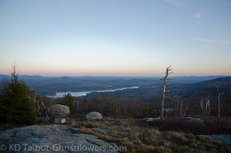
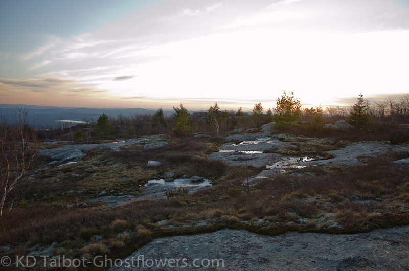
Alton Bay at Sundown from Straightback Mountain

Straightback Mountain 1910' / Mount Anna 1670' / Mount Mack 1945' / Mount Klem 2001' / Rand Mountain 1883' / West Quarry Mountain 1894' / East Quarry Mountain / North Straightback

From Jesus Valley Road: Purple Trail/ Turquoise Trail/ Blue Trail/ Red Trail/ Mount Klem Loop/ Quarry Trail (Maybe some others, too)

10.5-11 Miles 3200' Elevation gain

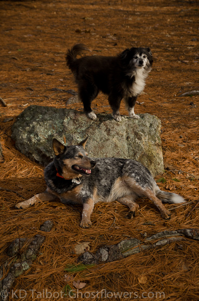
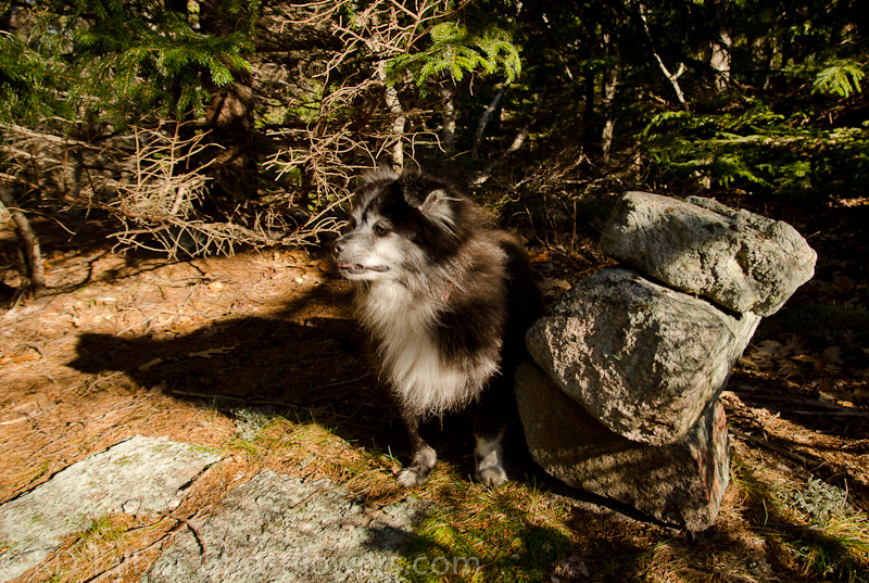
Kevin, Judy, Emma and Blue


After dozens of trips to the Belknaps we decided it was high time we actually finished the list of hills that makes up this beautiful range. Some of the hill tops are what might be considered "Official", meaning they appear and are named on the USGS Topo maps, while others are considered "Unofficial" meaning they were given names by such entities as the local Boy Scout Camp. Although only one hill reached an elevation over 2000', it was apparent while making this hike that it made little difference if we were hiking an "Official" named hill or not. The fact was that each had its own character and each provided sections which were alternately difficult, moderate and sometimes easy. The north side of several of the hills were actually steep, difficult rock scrambles that by the end of the hike were becoming increasingly taxing on body and spirit.

There is now a pretty good map of the Belknap Range online at:

http://belknaprange.org/belknaprangemap.htm

It should be noted that it may contain some inaccuracies. Of important note is that trail colors on the map were used only to identify different trails and do not pertain to the colors used for blazes along each trail. With all that in mind we were able to plan a loop hike across this range which included Mack, Klem and West Quarry, all of which were objectives we wished to achieve to complete our Belknap list. As I stated above the loop was approximately 11 miles long with an elevation gain in the vicinity of 3200'. This proved more difficult than what we had imagined in that the elevation gain was spread out over the entire 11 miles whereas many hikes that may be longer with more elevation gain tend to be downhill after the summit goal is achieved.

20111203-_DSC0007.jpg

Emma Leads

We chose the nearest trailhead to our home to save travel time so, starting out from Jesus Valley Road we made the short, steep climb to Straightback Mountain. Having once been a blueberry farm the summit is very open and scarce of tall trees which allows for great views in most directions. There was a skim of ice on puddles which mostly melted away during the warm day which stayed in the high 30's to low 40's with never more than a breath of air all day. Emma and Blue were quite happy with the cool temps and moved along at a very good clip throughout the hike. If Emma did eleven miles, then Blue did probably a couple more as he darted after every forest scent that presented itself throughout the day.

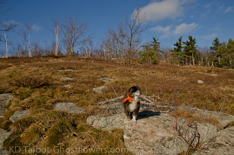
Over the years Emma has learned that conserving her energy is an important factor to be successful during these long hikes. At her age she has become a master of the "conservation of motion" during our hikes. Not so with young Blue, a happy go lucky three year old who takes great joy in his mountain hikes. On this hike he was afforded the chance to zig-zag his own trail back and forth across the human herd-path, thus striking fear into the hearts of both red squirrel and grouse alike. He has reserved a lot of pent up energy for these hikes as his momma is still in the slow healing process from a fractured sacrum suffered when she was knocked flying by dogs at the dog park. She is coming along well but isn't ready for the rigors of the trail and in the meantime Blue looks forward to his excursions with his foster mom and dad and his big sister Emma.
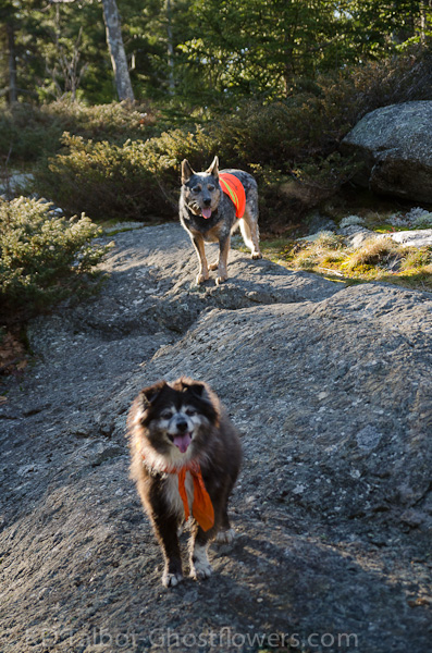
20111203-_DSC0050.jpg

Trail Buddies

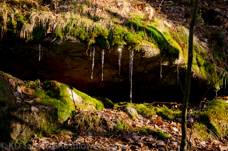
From the summit of Straightback we continued northwest dropping several hundred feet in elevation on the way to Mount Anna. On Anna we had a short break with lots of snacks and the dogs seemed very pleased that we had stopped. To this point we were hiking on familiar trails, but now we took a northerly direction and set out for new territory, what we refer to as "Redlining" even though it may not count towards any particular accomplishment. From here the trail dips way down into a saddle between Mount Anna and Mount Mack and there are several easy stream crossings through areas that are probably very wet after significant rain events and during spring run-off. The trail can be difficult to follow at some points and the addition of fallen leaves can add to the problem. However, the defoliated landscape of late autumn allows views towards the objectives and on a clear day navigation to each high-point should be pretty simple.

We reached the summit of Mack and sat down to have our lunch. We had been on the trail about three hours and we heard the first and only voices other than our own that we would hear until almost the end of the hike. We spoke briefly with two women on their way to Mount Klem. With a quick check of their map we concurred they were headed in the right direction and they were off. We saw them again briefly as we travelled in an opposite direction around the Mount Klem Loop. After we ate we chose a trail which led north across the summit of Mack where I was somewhat surprised to find a radio tower and some sort of windmill structure which appeared to have long since lost its usefulness.

20111203-_DSC0069.jpg

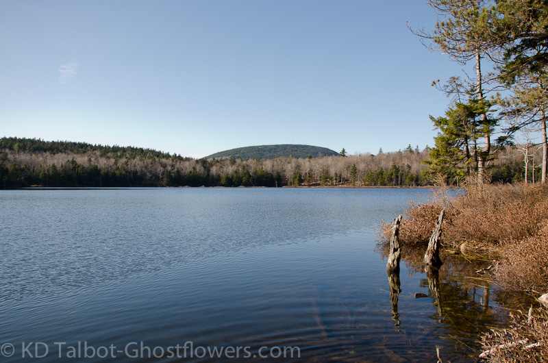
Beautiful Round Pond

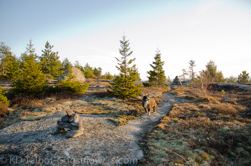
We descended to the edge of beautiful Round Pond, certainly worthy as a destination in itself and definitely not to be missed if one is visiting Mounts Mack and Klem. From the edge of the pond we picked up the Mount Klem Loop again. At a point along the trail I chose a herd-path which seemed to lead towards the high-point of Klem and judging by the fact that it led to a small cairn at what appeared to be the summit I would guess that we did indeed find the trail-less summit. Shortly after this we saw our two women hikers again passing in opposite directions and a little further on we came to a junction where I was pretty sure we wanted to turn east, but had some momentary confusion. After a brief trip continued along the Klem Loop to a nice southern outlook, we retraced our steps to the junction and began our trek east at the junction.

20111203-_DSC0073.jpg

Emma at the Mount Klem Cairn

We clamored down into another saddle and made a somewhat steep, difficult scramble up to the next high-point which I thought must be West Quarry, but it turned out to be Mount Rand. It had a very nice view from the northeast side out across Lake Winnipesaukee and Rattlesnake Island to the Ossipee Range and Mount Washington beyond. From here we clamored down another steep drop to another saddle which also had a steep scramble waiting for us on its southern edge. At the top of this scramble and well along the trail we came to a summit marker where I discovered that we had just climbed West Quarry and not East Quarry as I had initially thought.
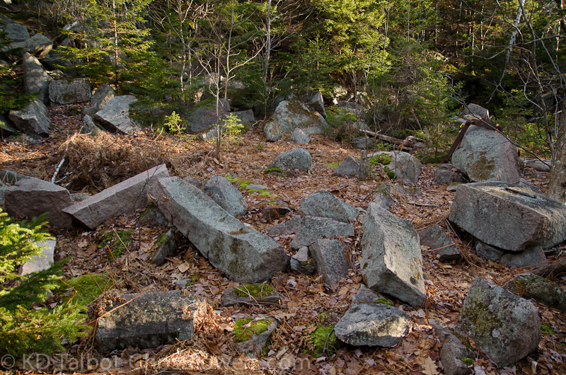
20111203-_DSC0085.jpg

In the Quarry

Another descent into a somewhat deep saddle brought us to the remains of the old granite quarry which gives this section of the range its nick-name, "The Quarries". A quick look around found quite a bit of evidence of the former quarrying operation. Many large slabs were piled around with obvious signs of having been cut from the living rock of these hills. Scattered about and marked with yellow surveyor's tape were iron implements that were once used when this operation was in full swing but were now left to be a part of the history surrounding these hills. We did not take as much time to explore this area as I would have liked as the hours of daylight we had left to complete this hike were now rapidly waning.

20111203-_DSC0089.jpg

December?

From the quarry there was yet another steep rock scramble up and then a winding, meandering trail led around and eventually across the high-point of East Quarry. There is still quite a bit of evidence of recent logging activity on the eastern slopes of East Quarry, though it is also obvious that mother nature is doing her best to reclaim this part of the range. There were a couple of tricky spots to negotiate as we passed through the logging cuts and roads, but we were now once again on previously travelled trails and knew the general direction we wanted to proceed in so passed through with little difficulty. Again we dropped down into a saddle, this time more shallow than the previous ones we had encountered, and here, between East Quarry and North Straightback we found all that remained of a once magnificent moose. All that was left were the sun-bleached bones, the head and antlers were gone to make trophy somewhere. Hide and meat were taken and hopefully put to good use and anything that was left was scavenged no doubt by the local coyotes whose presence was obvious along the trail throughout the hike. The dogs sniffed and looked at us as if to say "What happened here? Is this all that will be left of us one day as well?"
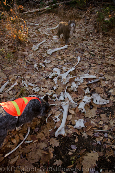
20111203-_DSC0097.jpg

The Lovely Bones

Continued:
 
Last edited:
Continued:

We made the short, steep scramble to the top of North Straighback. From here we could see east to Mount Major and out across Winnepesaukee to the Ossipees again. We knew we were close now to completing the loop back to Straightback where we could begin the final descent back to our car and it appeared we had made it in time to finish the hike in daylight, then the hike began to get interesting. On the ledgy plateau just northwest of Straightback Mountain, where the junction with the Quarry Trail is, we came across another hiker. He seemed somewhat flummoxed, but otherwise appeared in good shape. He approached us and began the conversation with, "Can you tell me what the shortest, easiest route off of this damn mountain is?"

Of course two dozen things raced through my head, but I was able to put them aside and asked, "Well, where are you parked?" The answer was at Mount Major trailhead. I said, "Well, if you come back this way with us you will come to the trail junction that will take you back that way." The answer was "I don't want to go back that way, I want down and off of these rocks. If you get me to a road I'll walk back to my car." I said, "Well, we're parked about 2 miles from here on Jesus Valley Road. If you can make it down to there I will drive you back to your car." His reply, "If you get me to the road we'll see. I can probably walk back." I said, "No, we'll drive you. It will be long and it's getting dark." He agreed to follow us out and decide what to do when we got to the car.

20111203-_DSC0104.jpg

Almost Back to the Start

I had sized him up when we met, something I don't like to do, but find is sort of automatic. He appeared to be OK, not exhausted or hypothermic. He had a small pack, contents unknown and he was well dressed for the weather, good hiking boots, he should be fine for the walk out, so thought nothing else as we crossed the summit of Straightback again and began the easy descent along an old tractor road. I would guess he was in his mid to late sixties. The sun was sinking quickly towards the horizon. As we descended he informed us that he had lost his way following the Blue Trail from Mount Major and was sure he would become benighted up here, so had called Fish and Game. "OK, so, where does that stand?" I inquired. "Well, I'm supposed to call them back. When I called 911 they told me to stay put, but I told them I was going to keep moving as the sun was setting and I was getting cold."

"Ok, well, you need to call them just as soon as we get down to let them know you're OK." "Well, yes, that's my plan." At this point I wasn't sure what to think. I didn't know if they would initiate a search, or wait to see if he got out on his own. As we dropped down off the ridge and into the trees again I thought I heard voices below us and then I was convinced I heard a motor. As we got closer I realized there was an ATV coming up the tractor road and as I approached what I had thought to be a hunting party turned out to be three members of the Alton Fire Department on their way to the summit of Straightback to search for our found hiker. As I approached they greeted us and one of them stated, "Too bad you're not the lost hiker we're looking for." I said, "Well, we found him, he's a little way back behind us and we're happy to walk him out and drive him back to his car." "That's great news," was the reply, "It's starting to get dark and the temperature is dropping."

20111203-_DSC0115.jpg

Setting Sun in the West

They made contact with the other agencies mounting the search, turned their wagon around and began to follow us back down. The found hiker at first refused to ride, but later decided he was quite tired and climbed on board for the last 1/2 mile or so. At the bottom of the trail we could see the red lights of a waiting ambulance in the woods at the end of Jesus Valley Road and we headed for that, but the adventure was not to end just yet. Catching a scent and giving in to instinct Blue darted off into the woods. Unlike previous forays he did not immediately return. I called and called. It was getting dark as the sun had now set. I admit I became somewhat irritated at his not returning, we were tired and ready to be through with hiking for the day. My first thoughts were he had gone off after a deer. I called some more. I knew he had a lot of pent up energy to burn and began to think he just wanted to keep going like another dog we walk. I thought, "He's pulling a Ruby. He doesn't want the hike to end, so he's off to extend it for awhile."


It was not the case. I called some more. In the mean time the ATV with passenger passed us and pulled up to the ambulance where a quick check showed the hiker was fine. Suddenly, Blue appeared. He ran up to us and as I began a verbal scolding he fell to the ground and wiped desperately at his muzzle with his front paws. We realized instantly the poor guy had been quilled. There in the half-light Judy tried to hold his head still while I pulled as many quills as I could from the poor guy's mouth. If you've ever seen a quilled dog you know what a horribly painful experience it must be for them. The lumbering pace of a porcupine must taunt the dog into an attempted bite, and once the muzzle makes contact it's all over. I can only imagine the startled snap back away and the desperate realization of searing pain, the poor guy. I proceeded to pull quills from his lips, gums, tongue, nose and the roof of his mouth. I would guess I pulled two dozen, each resulting in a spurt of blood from the injured spot. Though the removal obviously caused great pain, he never made a peep, brave dog.

20111204-_DSC0006.jpg

Next Morning

When we got to where I thought I had removed most of the quills we made our way over to the ambulance where we were thanked by the crew and the hiker, but I quickly explained that the dog had just been quilled and we had to be off to a vet to be sure we removed all the quills. The fire lieutenant told us he would drive the lost hiker back to his car and thanked us for our part in helping him down off the mountain. Sad part was we were about five minutes from our car when this all happened and if we had made it to the car poor Blue's pain would have been avoided. So, quickly climbing into the car we loaded our stuff and off we went towards home and the emergency vet we knew in the town next to ours. At the vet's there was a quick examination and after I signed the papers agreeing to pay the astronomical fees Blue was quickly brought into the surgery room where he was further examined, sedated, and had the rest of the quills removed. Within an hour we were all back in the car and made the final leg of the journey home. Once in the house both Emma and Blue plopped to the floor and barely moved again until next morning.

20111204-_DSC0018.jpg

My Bestest Boy Dog (Emma is Still My Bestest Dog!) by Linda

I had the pleasant task of calling Linda to inform her that once again Blue had found some mischief while in our care. I felt awful, but Linda was good about it and after discussing options said she would be out for him in the morning. Next day he was up and about and was ready to go again. We took a short morning walk through Kingston State Park where, apparently having learned nothing from the experience of the previous day, Mr. Blue bound off into the woods fast on the scent of small furry creatures. Much to our relief, he was quite himself again!

Full set of pics HERE:

KDT
 
Last edited:
that's quite a story!!! Glad everything turned out OK!!!! Liked the icicle picture.... such cute doggies!!!!!
 
Oh poor Blue. Terra got quilled a few years back and she also patiently allowed me to pull them out with my bare hands, trusting soul
That she is.
Glad to hear that everything worked out all around and next time
Pu-lease dont keep me
In suspense for 24 hours!!!!!

Betcha Blue doesn't so THAT again!
 
Thank you!

@ Becca- Emma is trying to teach her little brother the ways of the trail dog! Unfortunately, some lessons have to be learned by experience!

@ Una- I'm sorry! I figure, when I say I've got a story, people just roll their eyes and move on to something they'd actually be interested in... 8 ) Thanks for waitin' to see what my story was!

KDT
 
Nice photos as always and great to see a TR from the Belknaps. They are a great underrated and overlooked range I hike often and am glad to have as my local hikes. You certainly had an adventure, which can happen in those small hills. There have been a few rescues on major in the past few months surprisingly.

You aren't kidding about the coyotes. I always see coyotes scat, often fresh all around, especially in center section like Klem. I heard a pack yipping after doing some sunset photography on major and had another pack really close around piper, all within the last three months.

That map you posted is new and give a pretty good lay of the land, but still the one at the gilford library (right off 11A to Belknap Mountain Road) for $3 is way better because it has all of the obscure/defunct trails and roads on it too.
 
Thanks!

@ Cym- Glad you enjoy these!

@ John- Totally agree about these hills. We've had many great hikes across them. We go here a lot when time doesn't allow a trip to the Whites. Views across Winnepesaukee can be outstanding and equal to views from much higher hills.

Completely agree about the map. The one available at the library is superior in many ways, I just wish it was more widely available. The online one is good, but when printed out is difficult to read. It would be nice if there was a PDF version available that was downloadable of one of these maps.

I googled NHF&G to see if there was anything about our found hiker, I found nothing but, I did find an article from mid November stating there had been 13 rescue calls this year with at least 6 on Mount Major. The local Fire Dept. are becoming increasingly frustrated with these calls as the costs are passed on to the citizens of Alton. They are interested in better blazing along the trails and posting a map at the trailhead among other measures.

I should think that making these maps more readily available to the public would help with some of this, but I realize that most who get lost won't bother to have a map with them to begin with.

I like that buying the map helps the library. That said, I think I spent $2 at Castle in the Clouds for a detailed map of the trails there. Perhaps if the Belknap Map was available in more places more people would use it and not be as apt to get lost.

KDT

KDT
 
Great TR! Poor pup, porcupine encounters have got to be one of the worst things ever for a dog. :(

Funny story about getting lost in the Belknaps: My friend and I took a hike up Straightback on Easter Sunday (Jesus Valley road seemed like a good place to go that day :D), and totally missed the turn at the beginning of the trail! We ended up following a snowmobile trail for a 1/4 of a mile or so until it sort of faded away. I looked at the map and decided it would be impossible to miss the actual trail if we just kept going, so we did an impromptu bushwhack straight up Straightback! It was really nice actually, open hardwoods the entire way. I can totally see how people get lost in the Belknaps, though...

It sounds like you didn't miss the unmarked turn for the trail, after the marked turn/bike rails, before the other unmarked turns that led to snowmobile trails... :eek:
 
Snowmobile trails

We made that same mistake as well on an earlier trip, but we followed the snowmobile trail for quite a ways until it reached a tractor road, then followed up to Straightback. This tractor road eventually connects with the trail that you mention with the bike rails. That is the way the Alton Fire Dept. used to come up to look for the found hiker.

KDT
 
This one seems to fall into the "nothing is ever easy" category. What an adventure for one day! Great that you got the rest of the Belknaps - beautiful place. We'll have to get back someday to do the parts beyond what we did with you a last year. So great that you were able to help the poor guy who was about to be stuck out there. I'm sure the rescue crew would have gotten him but much better the way it worked out. So sorry for poor Blue. Tough lesson to learn. So great that the three of you have adopted him while Linda is mending. Give Linda our best when you talk to her and tell her we send our wishes for her recovery.
 
Top