
For a long time, my hiking bucket list has included Huntington Ravine and Boott Spur. New Hampshire welcomed me back from Vermont on Sunday with picture-perfect Presidential Weather. I hooked up with Marc Howes and we put these two goals into a loop, tagging Ball Crag as a bonus. Unbelievably, Marc had not been to either Boott Spur or Ball Crag. 9 miles and 4850 feet in 8 hours inclusive of stops.
(Note: I am pretty sure I named the gullies correctly, but please let me know if I have not.)
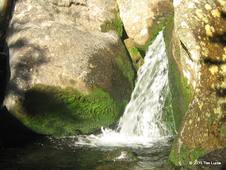
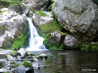
Cascades along the brooks which drain Huntington Ravine
We met at PNVC at 6AM and were under way by 6:15. It was cool and very uncrowded at the start and we saw nobody else along the ski trail to the split for Huntington Ravine. The lower section of the HR trail was twisty, rooty, rocky and includes several stream crossings along with a short detour onto the Jackson Ski Road. Just before the junction, we walked, amost literally, into a fox, who gave us a mildly irritated look and wandered off into the woods, no doubt planning to return to whatever we interrupted momentarily. From the road section, you can get a few glances at the headwall of the ravine which lies ahead.
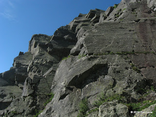
Looking up from The Fan (Pinnacle and Central), Pinnacle Gully from atop The Fan
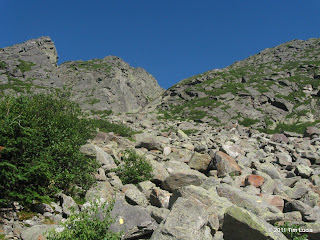
Presently the trail turns onto the lowest stretches of The Fan, boulders the size of SUVs or small houses even, with gaps between them that could easily swallow both of us. We snaked our way over, around and even under these boulders until breaking out of the trees completely and onto the talus field. The angle of the sun was such that we could make out a very thin glistening strip between the land and the sky which had to be the Atlantic Ocean. Looking up at the gullies (in awe, I might add) we saw some other people moving. One of them was hiking Huntington's as we were but the other two were making their way to climb Pinnacle Gully, (to the left of Central, the most-prominent feature in the ravine), with a narrow strip of water running down it. Sound carries well in the ravine and a not-so-loud shout got the climber's to look up at us and wave.
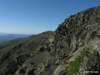
Pinnacle Buttress up close, Central With Boott Spur behind
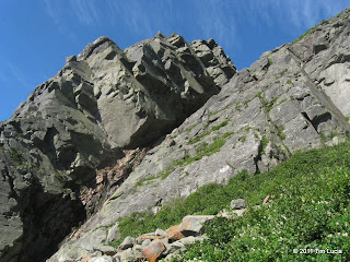
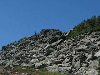
At the top of the talus field, we studied the slabs for a short while and then made our way up. While steep, they are not particularly smooth and it was not difficult to maintain contact. Marc kept his poles handy the entire time while I stowed mine and went with the four-legged approach. Above the slabs, it required careful attention to find and follow the fading yellow blazes. It was handy to have two people if there was any question which side of the next boulder to go on. I personally found this section to be the most challenging, even though the grade is not as steep. Being tall has advantages for taking tall steps, but it is disadvantageous when faced with tight spaces.
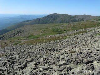
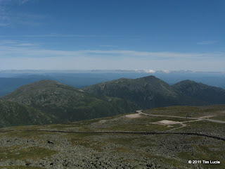
Across the Alpine Garden to Tuckerman and Boott Spur, Summit buildings from Ball Crag
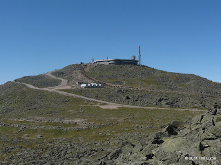
As we crossed the lip of the headwall, we were greeted with a bit more of a breeze, enough to help cool off and dry out from the prior effort, but not enough to induce a chill. The motorcycle and ATV riders coming up the auto road were all wearing heavy jackets and a few had on winter hats. Crossing the auto road we continued on to Ball Crag, a minor bump and the "other 6000 footer in New Hampshire." It does offer a straight-on view of the summit building which, like it or not, was kind of neat.
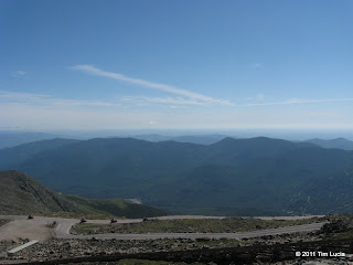
Mandatory summit shots: Northern Presidentials, Wildcat-Carter-Moriah Range
At the summit, we availed ourselves of the facilities which it offers and enjoyed lunch out on the observation deck. As predicted, the winds were light (5-15MPH) and the temps were nudging up to 60 degrees. The views extended well into Maine, including Elephant and Rangely, and north to Megantic in Montreal. After an extended break here, we wandered down the top portion of Tuckerman Ravine Trail, stopping to chat with the lot attendant (who was wearing Limmers and clearly has been hiking many times before.)
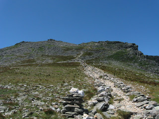
Boott Spur up close, Looking back from tree line
On the way down, we met up with the most other hikers we'd seen so far. With Tuckerman Ravine trail closed for maintenance, it seemed that the Boott Spur trail was getting a boost in popularity. Along the way we met some enthusiastic kids who warned us about the steepness and the gravel--we thanked them politely and assured them we would be OK. Along the descent there are good views of Lion Head, Huntington Ravine's northern wall, and the "left handed" view into Tuckerman Ravine. Turning 180 degrees offers an excellent view into the Gulf of Slides and over to Slide (Gulf) Peak. After returning to the trees, the trail offers several challenging obstacles, alternating with some flat spots which include bog bridges. We both went into autopilot (zombie) mode at some point and woke up when we returned to the ski trail just above Crystal Cascade.
All Photos
Tim
(Note: I am pretty sure I named the gullies correctly, but please let me know if I have not.)
Cascades along the brooks which drain Huntington Ravine
We met at PNVC at 6AM and were under way by 6:15. It was cool and very uncrowded at the start and we saw nobody else along the ski trail to the split for Huntington Ravine. The lower section of the HR trail was twisty, rooty, rocky and includes several stream crossings along with a short detour onto the Jackson Ski Road. Just before the junction, we walked, amost literally, into a fox, who gave us a mildly irritated look and wandered off into the woods, no doubt planning to return to whatever we interrupted momentarily. From the road section, you can get a few glances at the headwall of the ravine which lies ahead.
Looking up from The Fan (Pinnacle and Central), Pinnacle Gully from atop The Fan
Presently the trail turns onto the lowest stretches of The Fan, boulders the size of SUVs or small houses even, with gaps between them that could easily swallow both of us. We snaked our way over, around and even under these boulders until breaking out of the trees completely and onto the talus field. The angle of the sun was such that we could make out a very thin glistening strip between the land and the sky which had to be the Atlantic Ocean. Looking up at the gullies (in awe, I might add) we saw some other people moving. One of them was hiking Huntington's as we were but the other two were making their way to climb Pinnacle Gully, (to the left of Central, the most-prominent feature in the ravine), with a narrow strip of water running down it. Sound carries well in the ravine and a not-so-loud shout got the climber's to look up at us and wave.
Pinnacle Buttress up close, Central With Boott Spur behind
At the top of the talus field, we studied the slabs for a short while and then made our way up. While steep, they are not particularly smooth and it was not difficult to maintain contact. Marc kept his poles handy the entire time while I stowed mine and went with the four-legged approach. Above the slabs, it required careful attention to find and follow the fading yellow blazes. It was handy to have two people if there was any question which side of the next boulder to go on. I personally found this section to be the most challenging, even though the grade is not as steep. Being tall has advantages for taking tall steps, but it is disadvantageous when faced with tight spaces.
Across the Alpine Garden to Tuckerman and Boott Spur, Summit buildings from Ball Crag
As we crossed the lip of the headwall, we were greeted with a bit more of a breeze, enough to help cool off and dry out from the prior effort, but not enough to induce a chill. The motorcycle and ATV riders coming up the auto road were all wearing heavy jackets and a few had on winter hats. Crossing the auto road we continued on to Ball Crag, a minor bump and the "other 6000 footer in New Hampshire." It does offer a straight-on view of the summit building which, like it or not, was kind of neat.
Mandatory summit shots: Northern Presidentials, Wildcat-Carter-Moriah Range
At the summit, we availed ourselves of the facilities which it offers and enjoyed lunch out on the observation deck. As predicted, the winds were light (5-15MPH) and the temps were nudging up to 60 degrees. The views extended well into Maine, including Elephant and Rangely, and north to Megantic in Montreal. After an extended break here, we wandered down the top portion of Tuckerman Ravine Trail, stopping to chat with the lot attendant (who was wearing Limmers and clearly has been hiking many times before.)
Boott Spur up close, Looking back from tree line
On the way down, we met up with the most other hikers we'd seen so far. With Tuckerman Ravine trail closed for maintenance, it seemed that the Boott Spur trail was getting a boost in popularity. Along the way we met some enthusiastic kids who warned us about the steepness and the gravel--we thanked them politely and assured them we would be OK. Along the descent there are good views of Lion Head, Huntington Ravine's northern wall, and the "left handed" view into Tuckerman Ravine. Turning 180 degrees offers an excellent view into the Gulf of Slides and over to Slide (Gulf) Peak. After returning to the trees, the trail offers several challenging obstacles, alternating with some flat spots which include bog bridges. We both went into autopilot (zombie) mode at some point and woke up when we returned to the ski trail just above Crystal Cascade.
All Photos
Tim
Last edited:
