The Thoreau 14 - another new List

vftt.org

Help Support vftt.org:

This site may earn a commission from merchant affiliate links, including eBay, Amazon, and others.
rocket21 said:
Not only did a fence not stop Thoreau, but he *leaped* over it :)

I don't lightly take issue with the inventor of the Ossipee X List, but I would like to point out that Thoreau is not known to have jumped a fence or otherwise put himself so that he could claim a high-point. That same volume from which you quote includes his famous account of his hike to Ktaadn, where he was content to turn around some 1,200 vertical feet (best guess of some people) short of the Baxter Peak summit.

For something that mattered to him, such as a rare botany specimen, he'd do more than jump a fence. :)
 
Amicus said:
That same volume from which you quote includes his famous account of his hike to Ktaadn, where he was content to turn around some 1,200 vertical feet (best guess of some people) short of the Baxter Peak summit.

Jeepers, you'd be assuming I actually read the whole thing (instead of Googling his name and fence :) )
 
bcskier said:

I've now skimmed this earlier edition, thanks to our local library. Howarth later rewrote the Forward and Introduction rather extensively, but not the rest. I thought I had read that it had some maps not carried forward, but they turned out to be identical.

What this does have that were dropped are dozens of illustrations - woodcuts of the scenes Thoreau describes selected from 19th Cent. books and periodicals. I enjoyed these but wouldn't call them essential.

So, if you have any interest in Thoreau's mountain hikes but don't care to invest in your own copy of Walking with..., I think this would do nearly as well, if your library stocks it or you see it in a used-book sale.
 
Last edited:
Speaking of the Hooksett Pinnacle, why is it now closed to hikers, especially since it used to be listed in the Southern New Hampshire Mountain Guide? Did the land change hands, or was the peak becoming so trashed that visitors are no longer welcome?
 
Last edited:
RoySwkr said:
There were no fire towers anywhere in NH or perhaps the world in Thoreau's time so of course he didn't climb any. I merely thought that the peak selected for the tower was probably the one thought to have the best view.
The oldest known fire tower was Masada, "It was built by King Herod's army in Palestine (TFR: about 2,000 years ago!) to protect against his enemies who were burning his empire." (from Wikipedia).

I know NYS had towers in the 1880's, but I could not find any references to other towers in the 1800's with quick search.
 
Tom Rankin said:
The oldest known fire tower was Masada, "It was built by King Herod's army in Palestine (TFR: about 2,000 years ago!) to protect against his enemies who were burning his empire." (from Wikipedia).

I know NYS had towers in the 1880's, but I could not find any references to other towers in the 1800's with quick search.
Someone you know can tell you which fire tower in the Catskills is often claimed to be the oldest forest fire lookout site in the US. Before the late 1800s, forests were often burned deliberately to clear land and they weren't considered worth protecting - if they burned, there were more somewhere else.

The earliest fire lookouts were in urban areas where buildings were valuable and human lives were at stake. They were often in fire stations although I saw a postcard of a cast iron free-standing tower in NYC. I'm not sure how many forests were near Masada, perhaps it was crops or cities they were burning.
 
Perhaps this should be a separate thread, but there is also the "I Have a dream" peaks from one of Martin Luther King's speaches. The mountains he named are: 1. Mt. Whitney, 2. Mt. Elbert, 3. Mt. Washington, 4. Mt. Marcy, 5. Mt. Davis, 6. Lookout Mountain, 7. Stone Mountain, and 8. Woodall Mountain. The peaks range from 14,495 feet down to 806 feet.
 
eruggles said:
Perhaps this should be a separate thread, but there is also the "I Have a dream" peaks from one of Martin Luther King's speaches. The mountains he named are: 1. Mt. Whitney, 2. Mt. Elbert, 3. Mt. Washington, 4. Mt. Marcy, 5. Mt. Davis, 6. Lookout Mountain, 7. Stone Mountain, and 8. Woodall Mountain. The peaks range from 14,495 feet down to 806 feet.
Yes, I had also thought of the "I have a dream list" when I first saw the Thoreau list. When Amicus is satisfied with the complete list, perhaps it should be sumitted to the Peakbagger website for inclusion in the Miscellaneous peak lists.

Some of the mountains in the Dream list (Lookout and Stone) were specifically mentioned near the end of the I have a Dream speech. Others were generally referenced as in "prodigious hilltops of New Hampshire". A representative or highest mountain was then selected from that reference.

The potential for literary peak lists could be endless. The Thoreau list inspired me with the thought of a John Burroughs list for the Catskills and Hudson Valley (but it would include other areas as well). Like the Thoreau list it would be a considerable effort. Perhaps I will work on it some day after I finish finalizing a few other peak lists on my plate. I would not be upset if someone else beat me to the Burroughs list.
 
Last edited:
Mark Schaefer said:
When Amicus is satisfied with the complete list, perhaps it should be sumitted to the Peakbagger website for inclusion in the Miscellaneous peak lists.

That website is new to me (as is the "I Had a Dream" List). I don't think any new information on Thoreau's peaks is likely to emerge any time soon, so I guess I will submit as is, except that I intend to make South Mtn. in the Catskills # 17, since I find Mark Schaefer's arguments pretty persuasive. While it seems that Thoreau did not reach a summit in the Ossipee Range, he probably got closer, in vertical feet, than to Baxter in Katahdin, so I'll probably leave it, making it Mt. Shaw as the generally recognized "Ossipee Mt." (Thoreau's term), and (incidentally) a great view-hike.
 
Amicus said:
While it seems that Thoreau did not reach a summit in the Ossipee Range, he probably got closer, in vertical feet, than to Baxter in Katahdin, so I'll probably leave it, making it Mt. Shaw as the generally recognized "Ossipee Mt." (Thoreau's term), and (incidentally) a great view-hike.

Throeau in 1857 - "It is not worthwhile to go around the world to count the cats in Zanzibar, unless you count and visit 10 peaks in the Ossipees." :)
 
RoySwkr said:
Someone you know can tell you which fire tower in the Catskills is often claimed to be the oldest forest fire lookout site in the US. Before the late 1800s, forests were often burned deliberately to clear land and they weren't considered worth protecting - if they burned, there were more somewhere else.
That would be BLM! :)
 
rocket21 said:
Thoreau in 1857 - "It is not worthwhile to go around the world to count the cats in Zanzibar, unless you count and visit 10 peaks in the Ossipees." :)

I see you have your hands on what must be a draft of Walden. I'm impressed, and I suppose I'm sorry he (or his editor) lost the "Ossipees" reference in the published text, but that version is a but punchier.

Another good thing he is said to have said that is relevant here:

On tops of mountains, as everywhere to hopeful souls, it is always morning.

(I can't verify that, but it sounds like him.)
 
Amicus said:
While it seems that Thoreau did not reach a summit in the Ossipee Range, he probably got closer, in vertical feet, than to Baxter in Katahdin, so I'll probably leave it, making it Mt. Shaw as the generally recognized "Ossipee Mt." (Thoreau's term), and (incidentally) a great view-hike.
If Thoreau's route from Red Hill to Tamworth approximated today's Rte.25, his high point would have been about 750' which is 2200' and 5 miles from the summit of Mt Shaw and only a quarter of the rise from sea level. How far did you say he was from Katahdin? And I don't see why the Ossipee 10 and Thoreau peaks can't be disjoint sets.
 
RoySwkr said:
If Thoreau's route from Red Hill to Tamworth approximated today's Rte.25, his high point would have been about 750' which is 2200' and 5 miles from the summit of Mt Shaw and only a quarter of the rise from sea level. How far did you say he was from Katahdin?

I don't think Thoreau's route approximated Rte. 25 and Shaw is not the "Ossipee Mountain" I had in mind. Thoreau says he rode along the west and northwest side of Ossipee Mountain for a long afternoon, until he wondered when he'd be done with it. That sounds less like Rte. 25 then 108 and 171 to a point maybe south of Mt. Roberts, then north along something like Ossipee Mt. Road (appropriately enough), tracing the W and NW sides of the Range. Roberts would be my summit, although any of the Ten would do for purposes of this list.

So, I've raised my point reached and lowered my summit not reached, compared with yours. Still, the gap may be greater than the 1,200-foot shortfall Howarth believes existed for Katahdin.

So, I don't dismiss your point. I'll have to take it up with the Committee, of course, but the present 17 may shrink by one in the next iteration.
 
If you had a hard time finding it like me it's on page 6 "Transcendental Tourists"

Regarding the article - page 2 'Today'sWord': grok. Seems appropriate
 
carole said:
Regarding the article - page 2 'Today'sWord': grok. Seems appropriate

Change "grok" to "grouch" and I heartily agree. :) The author seems to be one of those tedious "Massh*les Go Home!" types (not very numerous, in my experience) and I detected no humor in his account. Incidentally, he blames Thoreau and his "eastern Mass." friends for that Tuckerman's Ravine campfire that burned out of control, but it was the doing of their local guide, Wentworth, who ignored Thoreau's advice to remove piles of dried moss near where Wentworth was building his fire.
 
Amicus said:
Incidentally, he blames Thoreau and his "eastern Mass." friends for that Tuckerman's Ravine campfire that burned out of control, but it was the doing of their local guide, Wentworth, who ignored Thoreau's advice to remove piles of dried moss near where Wentworth was building his fire.

Interesting to hear the other side of the story. There are a lot of really slanted, negative editorials in that paper for sure. Nonetheless, I had a good chuckle from it.
 
Working the Thoreau 16 (Aug. 1 and 2, 2009)

Not to have hiked all the peaks on this List I compiled is a gap in my resume that I have determined to remedy. To that end, I hiked to four somewhat obscure summits in southern New Hampshire this past weekend. I enjoyed all four hikes in their own right, apart from connections to HDT.

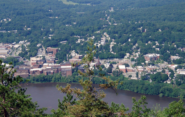
Wantastiquet Mtn. On a visit to Bronson Alcott (Lousa May's father) in Walpole, NH in 1856, Thoreau stopped first in Brattleboro, VT for a few days. He climbed "Brattleboro's mountain," known to him as Chesterfield Mtn. but now called Wantastiquet. It rises fairly steeply on the New Hampshire side of the Connecticut River and a west-facing view ledge near its summit gave and still gives impressive views of Brattleboro below and the mountains of southern and central Vermont beyond.

608992947_Qc9gW-M-1.jpg


608992599_SEpE4-M-2.jpg


The Trail leaves from the small parking lot for "Wantastiquet State Natural Area," reached in .2 mile by a dirt road that is your first left after you cross the bridge from downtown Brattleboro into Hinsdale, NH, just before a Wal-Mart. It winds in switchbacks for about two miles to the summit plateau, through attractive mixed woods.

608992033_PZd4V-M-1.jpg


Saturday morning, about half of the Trail was a stream and most of the rest was at least damp. A local I met on my way down who has been hiking there for years said it was the wettest he remembers. Still, I enjoyed both the hike and the views from the summit ledge, with its graffiti'd memorial to Walter H. Childs (whose memory seems otherwise lost even to Google). I took a herd-path east for about a quarter-mile to some ledges, ascending en route a knoll that may have been the north summit, but I gather from subsequent map-study that Mine Ledge must have been to my south.

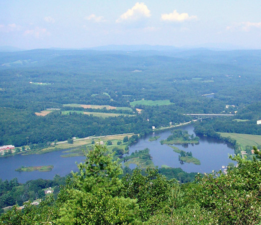
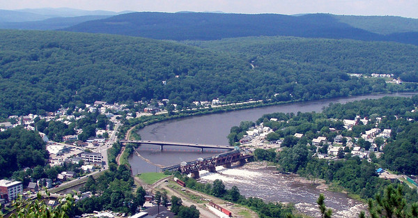
Fall Mtn. Twenty miles up the Connecticut, this steep summit dominates Bellows Falls, VT much as Wantastiquet dominates Brattleboro. What may be the same forest road that Thoreau followed leaves from the end of Mountain View Road in No. Walpole, NH (hometown of Hall-of-Famer Pudge Fisk), a little north of downtown. It winds up steeply to the summit in about one mile, crossing near its beginning a utility right-of-way, immediately after which you take a right-hand turn (a small pond will be on your left immediately after that turn).

As you approach the summit, you reach a fork, and the left will take you to the summit ("Mt. Kilburn" on the topo map), which offers a pair of cell-phone towers and hardly any views. The right takes you under power lines and, in about .3 mile, to a pair of ledges with great views from SW to NW, including Bellows Falls below. This fork ends at the more southerly ledge, which falls off steeply and is known as Table Rock.

608993690_u8PAu-M-1.jpg


The Uncanoonucs. That is a Native American word that signifies "pair of perfectly rounded [summits]." which is just how they look on topo maps, especially older ones. They overlook Manchester, NH from its western suburb, Goffstown, and Thoreau wrote so little about his hike there with his brother in 1839, on their trip to the White Mountains, that it cannot be determined which one they climbed. Each has fine trails, however, so I visited both on Sunday, en route from central NH to eastern Mass.

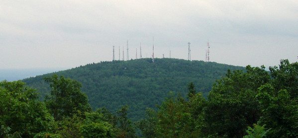
The trail to No. Uncanoonuc, blazed with white tin discs, climbs fairly steeply up the north slope, through a handsome hemlock forest and passing a mossy cave, reaching the broad summit meadow in .6 mile. I have read of trash, but good people have been at work, as I found a big fire-ring but no litter. The only decent view, however, was of So. Uncanoonuc, festooned with a fright wig of communications towers.

608995017_gVBbB-M-1.jpg


Several trails leave the Goffstown public beach, on Uncanoonuc Lake, for the summit of So. Uncanoonuc, and elsewhere a paved road permits you to drive there. The beach area served as base for a major ski operation in the 1930s - called by one "the St. Moritz of America" - that the interested can learn about on this http://www.nelsap.org/nh/uncanoonuc.html

I took the Incline Trail, which heads straight up to the summit road on the gravel bed of a sort of cog RR that operated for nearly 40 years, until sometime during WW II. While somewhat short on charm, it is direct. There were no very good views among the summit towers, nor at a clearing just off the Incline Tr. 100 yards below the summit marked by a "Viewing Area" sign. Another hundred yards or two down the Incline Tr., however, a side trail with the sign "Walker" heads west along the contour line for about .3 mile, before it turns right and starts heading down the mountain, due north. I think it must join the Summit Tr., which also goes up to the summit road from the beach area, but I didn't know about that then, so retraced my steps to the Incline.

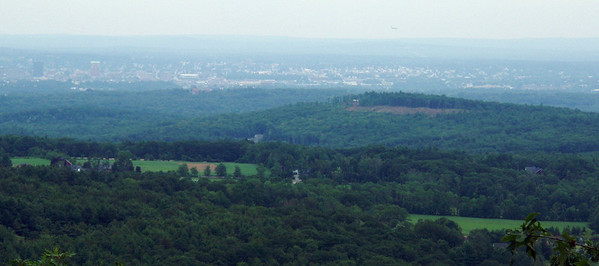
Ten yards from its junction with the Incline Tr., an open ledge on the Walker Tr. gave me a terrific view east to Manchester and beyond - by far the best vista on either of the Uncanoonucs, as far as I could tell. I hope to head back there to explore those other trails and enjoy that outlook on a clear day, perhaps in Fall colors.

608996279_fgja9-M-1.jpg


You can see the rest of my pictures here.
 
Last edited:
Top