Mt. Deception

vftt.org

Help Support vftt.org:

This site may earn a commission from merchant affiliate links, including eBay, Amazon, and others.

Jabberwalk

New member
Joined
Sep 18, 2008
Messages
112
Reaction score
25
Location
Holderness, NH
Now I know how this peak got its name!! It is quite deceiving!

Thanks to Doc Ross and others for their prior TR's which we found very helpful. I met my friend, Hufflepuff, in Twin Mountain and we proceeded to the Old Cherry Mountain Road. We parked at Camp 7 which is about 2.4 miles from Rt. 302.

Our plan was to follow the advice of several hikers to by pass the western summit by heading almost due east towards the main peak. This heading took us on a lateral traverse of the northern edge of the west peak. But, after 1.5 hours of steady progress through mostly open woods, littered with mossy rocks and blowdowns, we started to wonder. Could the massive peak above us possibly be the one we were looking for?? We could not resist the temptation to head up the hill. It was really steep and really high. Big mistake, too.

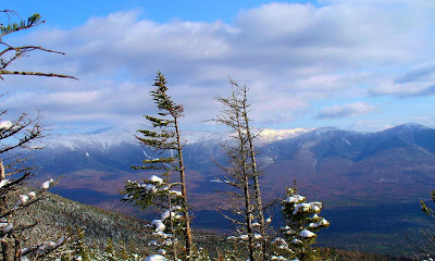
At the top we realized that it was the wrong peak, and we could see our target off to the east. I swear it looked lower than the peak we were standing on - very deceptive. The trip over to the main peak was not too bad, since we managed to stay to the north of the ridge, as recommended by other savvy hikers. We arrived at the top, which showed only 10 feet higher by my altimeter, in a little over 2 hours - not too bad for a couple of old ladies. :D
 
When we were there about 10 years ago, the ridge between the peaks had the remnants of a trail and was mostly easy going, especially on the eastern side of the col. We got lucky on the way back and found a logging road departing from the lower right edge of a large clearcut (which wasn't very clear) and it took us down to the car via a couple of zigzags.

An attempt several years before that from Jefferson Notch Rd and Mt Dartmouth got pretty tedious and we lost interest before we summited.

I wonder if there are any discernable remnants of the old Deception trail on the western side. Probably not, with the heavy logging in that area.
 
We arrived at the top, which showed only 10 feet higher by my altimeter, in a little over 2 hours - not too bad for a couple of old ladies. :D

Not bad for anyone, but your self-description is off. :) I've wondered about the old Deception Tr. too. A whole network went around there in the glory years of the Bretton Woods Hotel, before WW II. Probably no useful traces left?
 
Last edited:
I wonder if there are any discernable remnants of the old Deception trail on the western side. Probably not, with the heavy logging in that area.

There are still remnants of the old trail, but there are also blowdowns everywhere, and we had to clamber up and over quite a bit. Staying to the north side of the col seemed the best way to go. We were easily dissuaded from trying to do the whole ridge over to Dartmouth after reading prior reports of the difficulties between Deception and Dartmouth.

Yet overall, this is a very manageable BW. We never hit the REALLY thick spruce that occurs many times.
 
Thanks for posting your trek to the Deceptions (West and East). It’s always refreshing to see reports for some of the lesser visited peaks.

By any chance did you get the nice view of the Presidential Range from West Deception? Perhaps it’s one of those views that’s only available in winter (I've never been there in the summer).
Below is a winter photo taken from West Deception.
Prezies_fr_DeceptionWest.JPG
 
Not bad for anyone, but your self-description is off. :) I've wondered about the old Deception Tr. too. A whole network went around there in the glory years of the Bretton Woods Hotel, before WW II. Probably no useful traces left?

There were certanily traces of the old trail system left on what is now the "West Mountain". I used to instruct at BW in the 80's and in the fall & spring when there would be trace amounts of snow on the ground it tended to gather in old trail treads. There was also a path that followed the rough route of the water line. We found old pipe in various stages of being covered, which undoubtedly provided water for the old lodging house at the base. There were for a time even some old signs on a few very scattered trees. One could be found not too far off the conclusion of the then Glade West Trail. I'm sure with the development of the West Mt ski trails the last vestiges were lost, but for awhile it was there. I still remember a rather large pile of old pipe they pulled out of the woods. They gathered it in a heap at the base of the old looooooooooooong double chair.
 
There were certanily traces of the old trail system left on what is now the "West Mountain".

Good info. I think you once posted excerpts from a pre-WW II AMC Guide that described some of those trails. I've been to the top of Mt. Rosebrook, but that requires neither bushwhacking nor looking for those old trails, since BW's Rosebrook Chair dismount clearing extends to within 10 feet of it. The ledges you can see on Mt. Oscar from places like Middle Sugarloaf, which must be near the top of West Mtn., look like they're worth a visit.
 
Top