Stillwater Junction History Questions

vftt.org

Help Support vftt.org:

This site may earn a commission from merchant affiliate links, including eBay, Amazon, and others.

Becca M

Active member
Joined
Jan 31, 2008
Messages
854
Reaction score
102
Location
Pelham & Bristol, NH
Based on other threads, I got to thinking..... I've been through Stillwater Junction a few times, and I just *love* the name, first of all. But, I am still trying to picture the logging installation(s) equipment there.

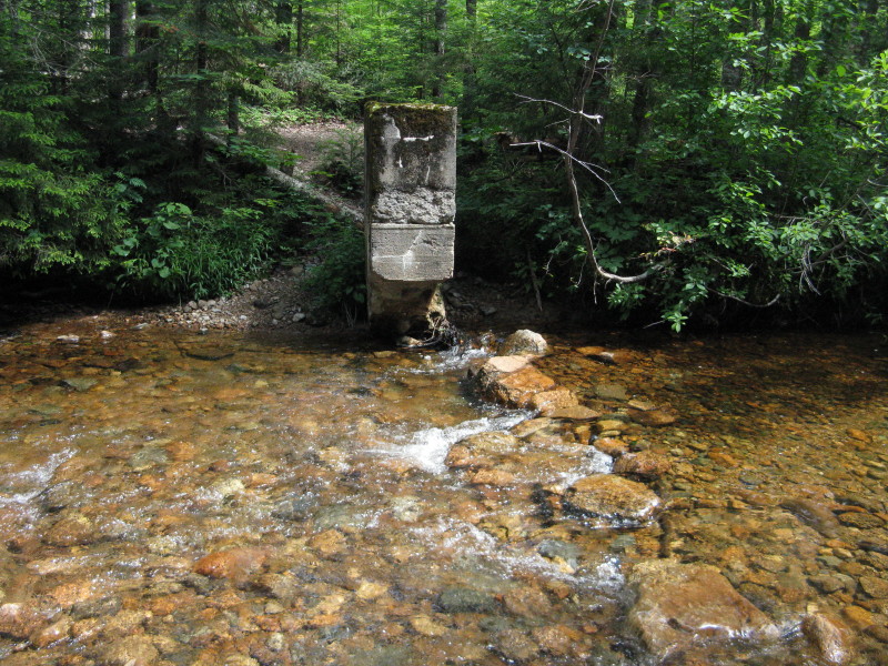
For instance, the large abutment-type thing(s) right at the crossing is/are (I cannot remember how many there were), according to the White Mtn Guide, apparently footings for some sort of dam. Any idea where the pond was? Obviously upstream, however, not being a civil engineer, I cannot imagine how big it was. Nothing is obvious to me when I've pondered from the crossing spot.

Also mentioned in another thread that there was a cable car nearby.... anybody looked around for footings?

Several RR lines crossed there - looks like another spur near the Stillwater Jct crossing - perhaps where an old trail went?

I've never found anything, but, I've only poked around for maybe 5 minutes... when i've been there during the day.... ;)
 
Stillwater map

Becca,
First place I'd look for the map you need is the book Logging Railroads of the White Mountains, by C. Francis Belcher. AMC Books, 1980.

Creag nan Drochaid
 
I believe this is the dam? The top of the concrete would give you a pretty good idea of the extent of the pond.
eastern%2Bpemi%2Bloop%2B167.JPG


From Steve Smith's blog entry
 
thanks guys!!! I have those maps and have checked out the blog, but, didn't know if anyone had more detail.... When I align the logging RR map with the current trail map, I cannot figure out with any detail where the actual old crossings were. I still ponder the concrete for the dam - didn't the RR cross there, too? Did it cross nearby or actually *on* the dam? That area supposedly has a LOT of crossings, but, I have never seen any metal in the area. It's so remote, you would think there would be some?
 
Last edited:
The crossings were probably all wooden trestles, so the only metal would be the rails, nails, and spikes. The rails of many of the lines were all pulled up in the big "retreat" by the railroads after logging. The spikes probably went with the rails. That would only leave the nails and other fasteners holding the wooden trestles together. Steel bits that small would have a good chance of rusting away to nothing, and if not, when the trestles invariably got washed away in a good storm ('38 ?) or collapsed of their own accord.

Note that I'm making this up, but it sounds good, doesn't it?
 
If you read the proper old guidebook, the Stillwater camp was not at the present Stillwater Junction but somewhat downstream and the 15' map shows it as a wide spot in the river :)

The logging RR used to make more crossings of the E Branch but the trail was moved to the S side, I hiked the old grade once and it was a lot muddier than I expected for a RR

I keep thinking that someday I will try to find the old Stillwater Bypass trail but haven't got to it yet
 
Based on JE Henrys reputation, the logging railroads were not built to last and the majority of the work was just good enough to survive the winter. Throw in the potential for storm events and the clearcutting of the basin, I expect that a couple of storm events since the area was active would be enough to wipe out a lot of the remains of the logging era.

Nevertheless a good resource is J&J from VFTT on what it out there.
 
Thanks guys!!!! GREAT info!!!! I basically agree with the temporary nature of the structures/installations given the power of nature. Cool WMG scan!!! However, if you compare this map

http://whitemountainhistory.org/uploads/eb_l_map.pdf

With current WMG maps, it is apparent there was a LOT of switching in that area (northwest of Carrigain).

OK, so the cable car was used at the camp - I wonder why they needed one there.

Also, why would there have been a dam there at the trail crossing site (not at the camp)? I am guessing for water intake for the engines given the river is so shallow there?

I know, I know, there are always more questions than answers.... just wish I had a "way-back" machine besides my old car... :)
 
Last edited:
I believe the dam remains are the remnants of the old Shoal Pond Brook water gaging station from about 1911. There are three of these old gaging stations around the Stillwater area. I believe there were seven of these gaging stations built around that time in the Pemi area.

They were part of a study done when the WMNF was being formed to determine the effect of deforestation on stream flows. The study was done for only about three years or so before it was shut down.

There are more remnants of a gaging station near the intersection of the Ethan Pond trail and the Shoal Pond trail. While standing on the bridge that crosses the North Fork on the Shoal Pond trail, look upstream (east) and there are some concrete abutments in the water where the gaging station used to stand. Storm Irene pushed at least one, if not both, of the abutments over so they are no longer standing.

John
 
Last edited:
OK, so the cable car was used at the camp - I wonder why they needed one there.

Okay, Dumb Question of the Day, but what exactly is a cable car? Like a mini-Tram? or a zipline of some description?

I love the Stillwater Junction area. Though I did the East Side Rd. approach the last time I was there, my favorite approach is through Carrigain Notch and down the Carrigain Branch. Next time I go I'm going to follow the Carrigain Branch all of the way down rather than staying on the trail. It's such a beautiful brook. I think I'll wait until Sawyer River Road is repaired, though. :p
 
Cable cars are often used for gauging stream flow, as shown here. This would be consistent with the dam/weir structures at Stillwater being used for stream flow measurements, rather than logging purposes.
CABLECAR.JPG

More info on cable cars and gauging at http://www.rickly.com/sgi/cable_cars.htm

BTW: Outside the US, this is referred to as a "flying fox"
 
Just happened to have scanned this for something else. From my 1936 WMG.


Note that it says the trail jct is "A few hundred yards above Stillwater"

You need the page for the Wilderness Trail to tell about Stillwater and the cable car

Cable cars are often used for gauging stream flow, as shown here. This would be consistent with the dam/weir structures at Stillwater being used for stream flow measurements, rather than logging purposes.
In this case the cable car was at the camp not the dam mentioned, there might have been another dam or maybe they just wanted an all-weather crossing at the camp
 
Awesome! Thank you, psmart.

If BeccaM ever gets that way-back machine she's got her heart set on, I just might have to hitchhike.

Cable cars are often used for gauging stream flow, as shown here. This would be consistent with the dam/weir structures at Stillwater being used for stream flow measurements, rather than logging purposes.

BTW: Outside the US, this is referred to as a "flying fox"
 
FUN FUN FUN info!!!! Yeah, getting that other page from the WMG would be cool!!!!

OK, so, cool info on the guaging stations - so, they weren't very big, then, at all. Technology has clearly changed from current guaging stations - I am thinking of the one on the Pemi River near the bridge in Plymouth - no dam there. ???? I would guess at Stillwater they dammed it off to see, based on inflow/outflow, how high the water filled - they must have had some sort of approximation/correlation info way back then????

Yeah, so, cable car was near the camp. Wonder why they chose a cable car - must have been for camp use only?

OK, so, hitchhikers *are* allowed on the wayback machine.... DougPaul will have to help me build it!!!! :) :) :)
 
Well at any rate, here are the 1936 WMG descriptions for Carrigain Notch and Shoal Pond. I had the last scan wrong - it was 1931.

Carrigain Notch 1


Carrigain Notch 2


Shoal Pond 1


Shoal Pond 2
 
LOVE the map - I am soooo going exploring next summer. It's time to stop saying I'm going to do it, and do it.

There was a Zeacliff Shelter?!?!?!
 
Top