Have You Ever Done a "Crippie" Hike? (09-Feb-2010)

vftt.org

Help Support vftt.org:

This site may earn a commission from merchant affiliate links, including eBay, Amazon, and others.

1HappyHiker

Well-known member
Joined
Jan 18, 2007
Messages
1,973
Reaction score
405
Location
Bethlehem, NH
Circumstances caused me to get another one of my "crack of noon" starts. With limited time available, I opted to complete some unfinished business. A few months ago, I combined a bushwhack with a hike up/over Mt. Langdon. My "unfinished business" was to complete the hike of all the other peaks along this short mountain range, i.e. Mts. Stanton and Pickering, plus the series of small peaks known as the "Crippies".

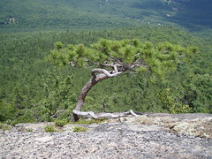
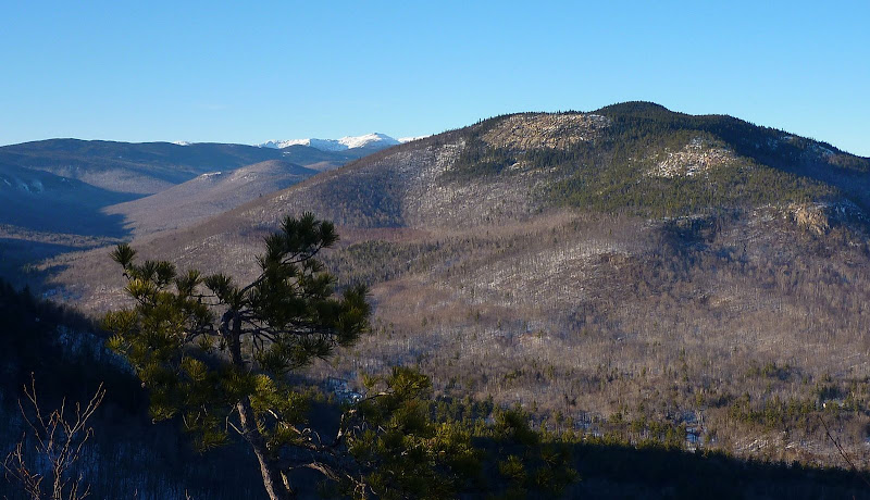
That name, "Crippies", is so bizarre! According to the WMG, "the origin of this peculiar name is one of the mysteries of White Mountains nomenclature." As I understand it, this term applies only to the group of 4 small peaks between Mt. Pickering and Mt. Langdon. For anyone unfamiliar with what a "Crippie" looks like, the 4th Crippie is shown in the center foreground of the photo below.

View of a "Crippie" (center foreground)
P1030958.JPG

There are no loop options available for this trek, and so the ideal way to traverse this range is to do what others on this Forum have reported doing, i.e. spot a car at the Mt. Stanton end, and at the Mt. Langdon trailhead in Bartlett. Otherwise, if you do an "out & back" hike as I did, you climb the mountains on the outbound portion of the hike, and then must re-climb them on the return. However, these mountains are not that tall, and so I didn't find it to be a big deal.

For me, this was an enjoyable hike, but it's probably not for everyone. From the outset, you must adopt the mindset that this isn't a true wilderness hike, nor is it considered as one of the all-time classic hikes in the Whites. However, it is still a hike worth doing, and there are views along the way that I found very pleasant and very interesting.

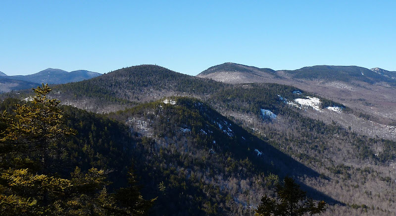
From several vantage points along the trail, there are some very nice views up the Rocky Branch Valley toward the Presidential Range. Although the photo below is slightly zoomed, these same features can easily be seen with the naked eye.

Looking Up Rocky Branch Valley Toward Presidentials
P1030999.JPG

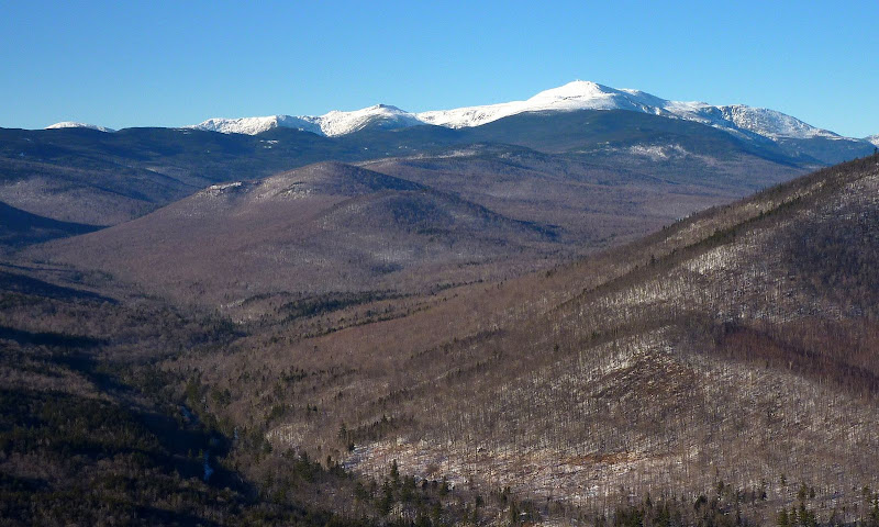
Particularly at the Mt. Stanton end of the hike, there are some good close-up views of the ledges on Iron Mountain (another great hike in this same area of the Whites!).

Ledges on Iron Mountain
P1040010.JPG

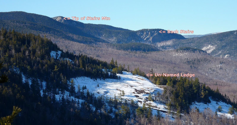
And speaking of ledges, I've labeled 3 features on the photo below. This will likely be mildly interesting ONLY to folks with an appreciation of trivia.:D Anyway, most everyone is familiar with Stairs Mountain with the unique "Giant Stairs" formation at its southern tip. Just to the east of Giant Stairs is a cliff which I think rock climbers have dubbed "Back Stairs". And, just to complete the tour of this photo, in the foreground there is a huge ledge. It's located on the east side of Mt. Langdon, and as far as I know, it has no name.

View of 3 Features for Those Who Admire Trivia
P1030986.JPG

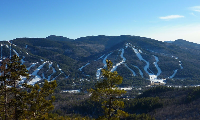
If you happen to have a particular liking for views of the Attitash Ski area, then this is definitely a hike for you!:D. All along the south side of the trail, there are scenes such as shown in the photo below.

View of Attitash Ski Area
P1030989.JPG

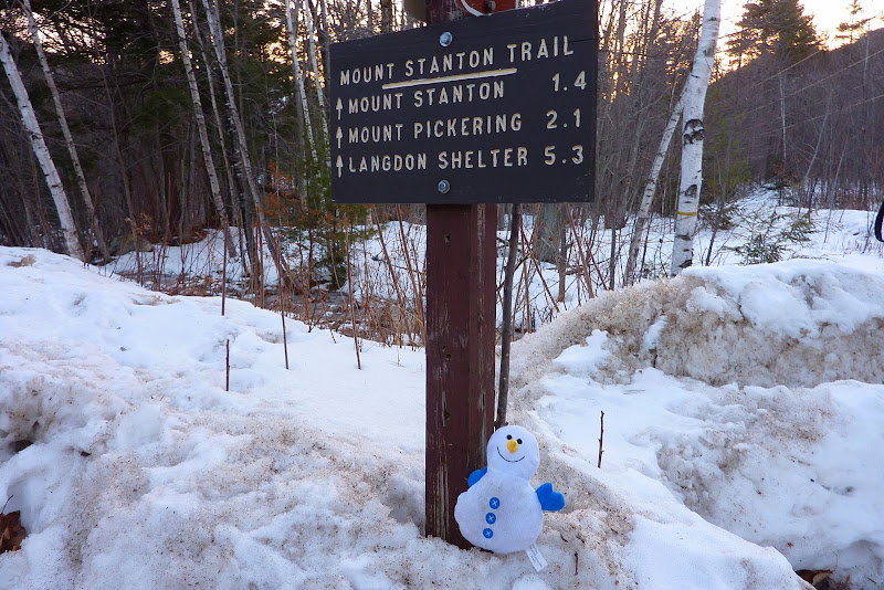
And last of all, I cannot guarantee that the cheerful little guy in the photo below will be there to greet you at the trailhead. I have no idea how this guy happened to be there, but he/she seemed happy performing the job as the official trailhead-greeter!:)

A Cheerful Trailhead Greeter
P1040012.JPG


1HappyHiker
 
Last edited:
Neat. I'm going to add this to the list for the kids when they aren't feeling like a 4K.

In photo 2 - to the left of Iron Mountain is Maple? and then behind and curving to the right we get to Engine Hill?

Tim
 
Crippies

John,
Another great report and terrific pictures. A few years ago we read about the hike in the WMG as we were looking for something a bit different. It turned out to be a great hike for the required effort. We did find it hard to determine when you were actually on a "crippie".
I looked up definitions for "crippie". Here are the results: high quality weed,
food cooked to a crispy texture, a disabled person, or a combination of "trippy and creepy". I don't think any apply to the peaks.
Anyway, I just like the sound of the word.

Donna:)
 
John,
I have on several occasions suggested to my friends that we traverse over the Crippies, but each time they have declined, in favor of bagging 4ks :confused:. To make matters worse, they are now trying to convince me to finish the winter 48 :rolleyes:.

This was a very cool and unique TR. Aside from the Attitash views, it seemed pretty wild and remote to me, too.

One question: how traveled was this route? My guess is that there wasn't much.

Regards,
Marty
 
That's a hike I've taken a few times. The first time was in the fall, sort of a scouting trip, and when I saw that there would be a lot of trailing arbutis (Mayflower) plants, I put it in as a AMC NH Chapter book hike for early May of the following year.

I don't remember how lovely the mayflowers were because what stands out in my memory is that the trail was extremely hard to follow because of the blowdowns that had occurred over a rough winter and I came away with a lot of bruises. So many, in fact, that my massage therapist was concerned when I went in for an appointment a few days later (my first with this therapist) and she said I should see my doctor to find out what was causing my extreme brusing! :p

The other thing I remember is that I had forgotten my boots and had to hike in my Tevas. Remember that, Kevin?
 
Donna: It's great to hear that you've also visited the Crippies, and that you found it to be a great little hike. Also, thanks for taking a moment to search for definitions of "crippie". Hmmm! Yes, I would agree that the definitions you found don't seem to fit these little peaks.

Marty: This was the first time I'd ever done this hike, and so I have no idea what is normal for this trail. However, on the day I did the hike, the trail was well tramped out to Mt. Pickerking. The consolided snow-pack (along with some brief icy sections) was ideally suited for microspikes. The trail from Mt. Pickering over the Crippies was not as heavily travelled and the snow was less consolidated. I switched to snowshoes, but probably could have continued on microspikes without postholing.

Ellen: Thank you for providing the information about the Mayflowers on this trail. Regarding the condition of the trail, there might have been quite a bit of maintenance since you were on it. There were no blowdowns of any significance, and it appears that the trail has been freshly blazed within the past year or so.
 
not what I thought at first...

from the title I was thinking 'crippies' was a term for Crippled Hippies, had visions of a Hunter Thompson-esque adventure...;)

A fun report nevertheless and some fine photography.
Thanks!
 
Thanks, John. Nice images! This is a good choice in spring for those of us who are itching for bare ground hikes. There are a few fine vernal pools between the Crippies and lots of dry bare trail.

happy trails :)
 
What a great TR and pictures, the one with Attitash Ski Trails is so cool!

We've done Stanton & Pickering in the summer only & have never seen another person!

Next time we'll have to head on over to the Crippies too
Thanks for a different perspective & more interesting version of this hike :)
 
Thanks and as always, nice report and pictures...love that area and the views from Stanton/Pickering and from Mt. Parker too...a nice trip would be from the Stanton trailhead to the Davis Path parking lot..something we are planning to do this coming year..
 
Michael: Thanks for your reply! Also thanks for your definition of "crippies", i.e. crippled hippies . . . I love it!:D:cool:

Forestgnome: Patrick . . . thanks for your suggestion about this being one of the first bare-ground hikes to open up in the Spring.
Dang! If we don't get any more significant snow soon, then we're going to have bare ground to walk on in many locations well before Spring arrives!!:eek:

Pocahontas: Tricia . . . glad you liked the report & photos. Thank you so much for your very nice words about the report!

Lefty E: That does sound like a very nice trip that you're planning from the Stanton trailhead to the Davis Path parking lot.

Another variation on that same general idea would be to go from the Stanton trailhead to the southern end of the Rocky Branch Trail at the Jericho Road trailhead. But regardless of which of those plans you might end up doing, try to make a point of including a visit to the southern knob of Mt. Resolution. There's a short 0.1 mile spur off the Mt. Parker Trail that goes there. There's a description of this in the current edition of the White Mountain Guide beginning at the bottom of page 67 and continuing over to page 68. I've been there and it's worth the small amount of extra time & effort.
 
Thanks for the great report John, I saw it on http://www.newenglandtrailconditions.com/ and had to read the report as this is a hike I was considering sometime soon and was wondering what the conditions might be. I did this hike in the summer to Pickering (http://www.flickr.com/photos/excape1/sets/72157621939756230/), wanted to continue on to the Crippies but it was hot & humid and the black flies were BAD! I enjoyed the intesting views on this hike and the beautiful wind stunted red pines looked like a Japanese garden.
 
Hey Jason . . . thanks for your reply!

You have a sharp eye to pick up on the rather small portion of red pine shown in a couple of the photos I posted. There are some very fine stands of red (Norway) pine along this route! With getting a late start, I didn't take time to shoot certain photos. There were a number of times when I thought about stopping to get out the camera and take some snapshots that featured the red pines since they were quite impressive. Oh well . . . there'll be other hikes and other opportunities to do this.
 
Actually (the red pines) I was referring to were the hike I did in August. You did get the tops of a few in a couple of your photos :)
3785323671_128ec0c575_m.jpg
3785338571_128fdff1e3_m.jpg
 
Great photos. I especially like the second one of the Rocky Branch Valley looking north.
 
Hikethesummits: Jason . . . My error! Upon re-reading your original reply I now see that you were referring to your trip, not mine!:)
Sorry 'bout that!

And, thanks for posting the snapshots of the red pines that you took on your trip along the Mt. Stanton Trail. Nice!

Hey . . . you might already know this, but just in case, there are also some nice stands of red pine along the upper portions of the Peaked Mountain Trail in North Conway. That's another short & easy hike that's quite nice!

DrJJFate: Glad you enjoyed the snapshots . . . and thank you for the kind words!
 
John,

Nice TR. I last hiked the Crippies about 1998 on a summer trip up the Montalban Ridge to Washington. It's a nice way to approach if you want to avoid the crowds! A bit off the beaten path. I recall napping at the Mt. Langdon shelter after an early start then coming across a mother bear on her cub on Parker. She was on her hind legs behind a tree peering at me with the cub high up a tree. I stayed at Resolution Shelter that night and heard some voices from the trail but otherwise no others all day. I believe it was on the Davis Path after Stairs where the trail became so overgrown that I couldn't see my feet on the trail. It felt like quite a remote hike in many ways - beautiful area.

Great pics.
 
I last hiked the Crippies about 1998 on a summer trip up the Montalban Ridge to Washington. It's a nice way to approach if you want to avoid the crowds! . . . It felt like quite a remote hike in many ways - beautiful area.
Raven, thanks for your reply. Your hike of the entire Montalban Ridge from Mt. Stanton to Mt. Washington is quite a significant trek.
I don't know where it ranks, but it's gotta be one of the longest ridge-walks in the Whites! It's nearly 20 miles from the south end of the ridge (beginning at Mt. Stanton Trail in Glen, NH) to the north end of the ridge at Boott Spur.

(And then after completing the 20-mile ridge-walk, you can add-on whatever extra miles it takes to turn it into a traverse-hike to some end-point destination of your choosing.):)
 
Last edited:
The other thing I remember is that I had forgotten my boots and had to hike in my Tevas. Remember that, Kevin?

Yup, I do Ellen. I'd never done that hike before, and one of the things that struck me were all the yellow lady slippers we saw up high along the ridges in rather thin soil. The only time I'd seen lady slippers (of any color) prior to that hike was in lowland cool, damp areas with lots of organic matter - places in the Pemi come immediately to mind. And I remember having to thrash about trying to find a way around all the blowdowns without completely losing the trail.

I also remember several people going for ice cream after the hike, and thinking the hike had been a good excuse for some to get the ice cream place in Bartlett in the late afternoon ...
 
Top