1HappyHiker
Well-known member
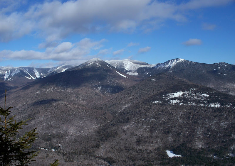
The photo below was taken from the ledges on the southeastern tip of Owl’s Head. I have no way of knowing for certain how many folks have ventured to this spot to experience this view. However, based purely upon postings from VFTT and other sites, I would seem that very few individuals have been privileged to witness this particular view of the Bonds.
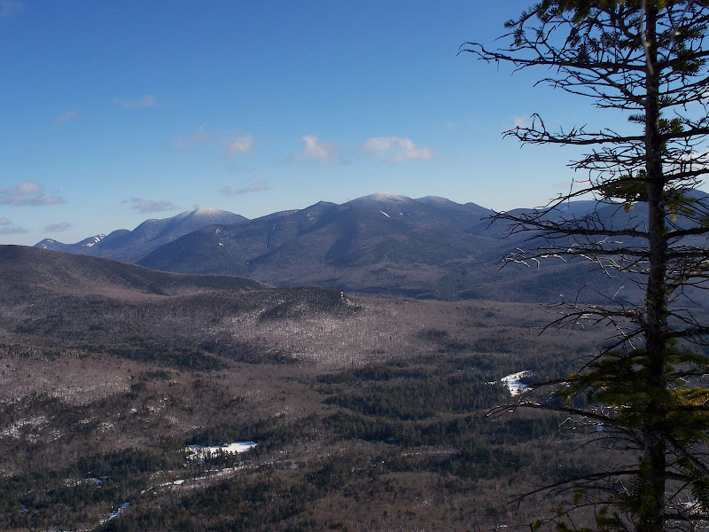
Before getting started with some details about the journey to this destination, here is one more photo taken from this spot with a unique view toward the area of the Hancocks and Carrigain.
Oh! And just one more thing before launching into some details of our trip! Chris (aka NeoAkela on VFTT) is not a photographer by profession, although I think he could be a professional photographer if he so chose! I fully expect that he will be posting some photos that he took during our trek, and they should be phenomenal!
OK, now for a few details about the trek. Two friends (Steve and Chris) and I set off on this adventure to Owl’s Head on 27-Jan-2009. However, as mentioned above, our destination was not the summit of Owl’s Head. Instead, we opted to embark on a bushwhack to the ledges on the south end of Owl’s Head. Steve had been to these ledges on other occasions and raved about the views from there.
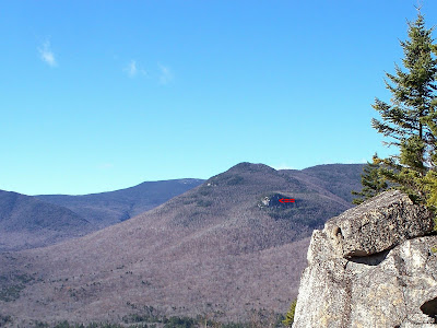
Below is a photo (taken from another location on another trip) with a small red arrow pointing to the ledges we visited.
It was 6 degrees when we started, but we knew it would be warming up to the high teens. So, off we went at a good clip down the Lincoln Woods Trail. The views walking along the Pemi River are beautiful. However, this old logging railroad bed can soon become pretty boring unless you’re either doing it with other folks, or else you put yourself into a trance-like state if you’re doing it alone!
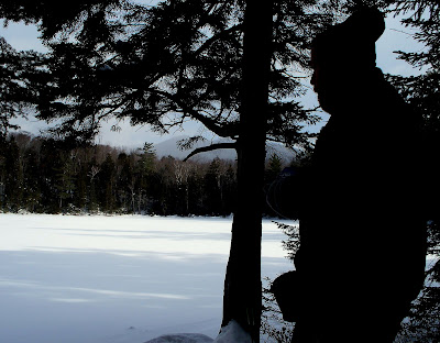
In a relatively short time we reached the Black Pond Trail junction. We were enjoying terrific hiking conditions: cool, very light breeze, and clouds which were beginning to clear. Once we reached Black Pond we stopped for a snack-break and the usual photo-op of Owl’s Head over Black Pond, etc. Below is a silhouette of a member of our team at Black Pond taking a break.
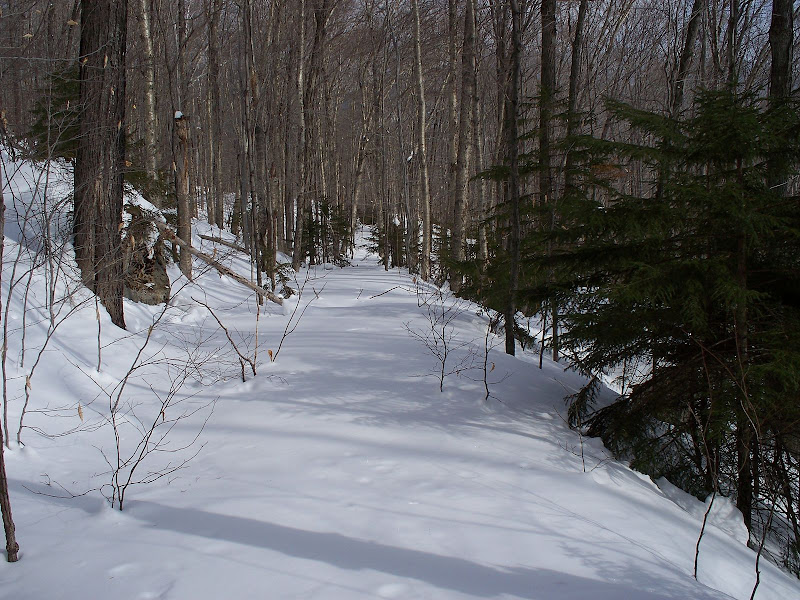
The bootleg trail at the end of the Black Pond Trail was well broken out and quickly traversed. But, once we met up with the Lincoln Brook Trail, this is where our course of travel differed from those who would be going to the summit of Owl’s Head. Instead of continuing on the Lincoln Brook Trail, we crossed Lincoln Brook on very firm ice-bridges and then began our northward whack to the ledges. The whack up to the ledges was through mainly open woods with some beautiful birch glades. Parts of the whack were quite steep, and slippery snow conditions made for slow-going even with 3 of us rotating trail-breaking duties.
As indicated at the top of this report, we made it to our destination and got some incredibly unique views. But eventually, we had to rip ourselves away from ledges and begin the long trek back (roughly calculated to be about 6 miles staring us in the face!) Whenever you bushwhack and use bootleg trails such as the trail leaving from Black Pond, it’s difficult to calculate mileage with great precision. However, we guesstimated that this round-trip trek was somewhere in the vicinity of 11 to 12 miles *.
During our return, the nearly 3-mile long “Lincoln Woods death march” was traversed in the dark. But, it was a perfectly clear night and even though there was only a sliver of a moon, the light from the stars provided enough dim light so that it was unnecessary to use headlamps. And, to top off an already fantastic day, we saw a shooting star streaking across the sky just as we were approaching the Lincoln Woods trailhead!
1HappyHiker
* Subsequent to the original posting of this report, Chris was able to get a better fix on the original “guesstimate” for the trip mileage. Data from his Garmin 60Csx track-log showed a total distance of 13.8 miles. So, even if you were to deduct a few tenths of a mile from the GPS data for device recording errors, etc, it appears that the distance for this trek was at least 13 miles.
Before getting started with some details about the journey to this destination, here is one more photo taken from this spot with a unique view toward the area of the Hancocks and Carrigain.
Oh! And just one more thing before launching into some details of our trip! Chris (aka NeoAkela on VFTT) is not a photographer by profession, although I think he could be a professional photographer if he so chose! I fully expect that he will be posting some photos that he took during our trek, and they should be phenomenal!
OK, now for a few details about the trek. Two friends (Steve and Chris) and I set off on this adventure to Owl’s Head on 27-Jan-2009. However, as mentioned above, our destination was not the summit of Owl’s Head. Instead, we opted to embark on a bushwhack to the ledges on the south end of Owl’s Head. Steve had been to these ledges on other occasions and raved about the views from there.
Below is a photo (taken from another location on another trip) with a small red arrow pointing to the ledges we visited.
It was 6 degrees when we started, but we knew it would be warming up to the high teens. So, off we went at a good clip down the Lincoln Woods Trail. The views walking along the Pemi River are beautiful. However, this old logging railroad bed can soon become pretty boring unless you’re either doing it with other folks, or else you put yourself into a trance-like state if you’re doing it alone!
In a relatively short time we reached the Black Pond Trail junction. We were enjoying terrific hiking conditions: cool, very light breeze, and clouds which were beginning to clear. Once we reached Black Pond we stopped for a snack-break and the usual photo-op of Owl’s Head over Black Pond, etc. Below is a silhouette of a member of our team at Black Pond taking a break.
The bootleg trail at the end of the Black Pond Trail was well broken out and quickly traversed. But, once we met up with the Lincoln Brook Trail, this is where our course of travel differed from those who would be going to the summit of Owl’s Head. Instead of continuing on the Lincoln Brook Trail, we crossed Lincoln Brook on very firm ice-bridges and then began our northward whack to the ledges. The whack up to the ledges was through mainly open woods with some beautiful birch glades. Parts of the whack were quite steep, and slippery snow conditions made for slow-going even with 3 of us rotating trail-breaking duties.
PHOTOS OF LINCOLN BROOK CROSSING & TRAIL-BREAKING
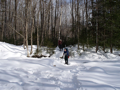
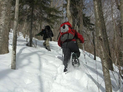
(Trail-Breaking Photo courtesy of Steve)
Along the way to the ledges we crossed over a century old segment of a former logging railroad located high above the current day Lincoln Brook Trail. As I understand it, this railroad traveled sort of a U-shaped route around the southern end of Owl’s Head. It’s amazing that with so many years having passed, the path of this old railroad is still quite discernable. (See photo below.)
As indicated at the top of this report, we made it to our destination and got some incredibly unique views. But eventually, we had to rip ourselves away from ledges and begin the long trek back (roughly calculated to be about 6 miles staring us in the face!) Whenever you bushwhack and use bootleg trails such as the trail leaving from Black Pond, it’s difficult to calculate mileage with great precision. However, we guesstimated that this round-trip trek was somewhere in the vicinity of 11 to 12 miles *.
During our return, the nearly 3-mile long “Lincoln Woods death march” was traversed in the dark. But, it was a perfectly clear night and even though there was only a sliver of a moon, the light from the stars provided enough dim light so that it was unnecessary to use headlamps. And, to top off an already fantastic day, we saw a shooting star streaking across the sky just as we were approaching the Lincoln Woods trailhead!
1HappyHiker
* Subsequent to the original posting of this report, Chris was able to get a better fix on the original “guesstimate” for the trip mileage. Data from his Garmin 60Csx track-log showed a total distance of 13.8 miles. So, even if you were to deduct a few tenths of a mile from the GPS data for device recording errors, etc, it appears that the distance for this trek was at least 13 miles.
Last edited: