Why is the number '19' posted on many trees on the Avalon trail?

vftt.org

Help Support vftt.org:

This site may earn a commission from merchant affiliate links, including eBay, Amazon, and others.

mirabela

Active member
Joined
Apr 2, 2008
Messages
582
Reaction score
53
Location
Northeast Kingdom, VT
We saw many trees with white stickers / black letters numbered '19' on this trail, and at least one sticker with the number '24' on the A-Z. Any idea what these mean?

Thanks --

Matt
 
I was wondering the same thing myself. I just assumed that everyone knew what it was all about, except for me!:confused::)

Below is a photo of one such tree that has the number 19 posted on it.
Number_19.JPG
 
I'm told there's a 22 out there as well. I was wondering if there's a map the Highland Center might have that indicates the trails by numbers instead of names? Maybe a nature walk kind of thing?
 
*Might* be the boundary of a timber sale. There are often numbers painted at the boundary of each "unit", but I've never seen them done this way. Would have to check with the USFS. I can't think of any other allowed use for this type of marking.
 
*Might* be the boundary of a timber sale. There are often numbers painted at the boundary of each "unit", but I've never seen them done this way. Would have to check with the USFS. I can't think of any other allowed use for this type of marking.

I tend to agree with this since the splash of blue paint seems to be commonly used to mark trees for cutting or cutting limits.

If you want to see some really bizarre use of paint markings on trees, attempt to follow the abandoned Stevens Brook Trail that runs up over the southern end of Mt Carr. The trail runs from the Plummer Rocks Geologic area on Buffalo Road in Rumney over the HOL to Stinson Lake Road through the basin drainage. The area is identified as the Carr Mountain Inventoried Roadless Area. I believe it was inventoried using many spray cans of colored paint.
 
I saw #77

on 1/8 I was hiking down the Carter Moriah Trail late in the day and in last 1/2 mile recall seeing same style number. I think it was #77. Alas I didn't take a picture of it. I think it might have had some blue paint also, but don't recall exactly.
 
We saw some metal tags on trees on the Starr King trail in late December last year. I believe they are used to delineate bird study plots. We saw the same stickers on the Avalon trail so maybe they are also for bird study plots?
 
Are they possibly related to geocaching or some orienteering group?
 
Doesn't look like LNT was practiced...
 
There's a '38' with bright orange paint very similar to that on Oak Ridge. But since that's not a 4k I'm not surprised that no one else noticed it. I assume it's related, not have no idea what it's for.
997137505_GRfAb-S.jpg
 
Last edited:
Are they possibly related to geocaching or some orienteering group?

Would not be orienteering. For one thing, orienteering markers are orange and white triangles in a square. Secondly, no orienteering map of that area that I know of.
 
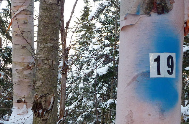
I contacted the WMNF's Marianne Leberman, Recreation & Wilderness Program Leader, about the 19s on the Avalon Trail - here's her response:

"I have verified with the different Districts and departments here on the Forest that these are not anything that has been authorized by us. They have been found in numerous areas around the Forest. Our law enforcement officers have been trying to find out who has been doing this but as you can imagine it is a difficult thing to do. Again, this action is unauthorized and we will remove them as we are out doing trail maintenance."
 
Raven-"Are they possibly related to geocaching or some orienteering group?"
They are definitely not associated with geocaching and anything like that wouldn't be allowed, plus there are no geocaches near Avelon.

It might be prudent to stop pointing fingers at any other group that uses the outdoors and actually wait to see who is responsible.
 
Top