12,000 Ossippee acres closed

vftt.org

Help Support vftt.org:

This site may earn a commission from merchant affiliate links, including eBay, Amazon, and others.
Having thought about this a little more, and seen the actual language of the posted signs, I think that it is quite evident that the poster of the signs is an authentic lunatic. Noone posts damaging inferences connected to someone else's name in public places, and no sign is valid unless signed by the poster.
Moreover if anyone went to the trouble of reading the explanations, advice and stated purpose as presented on the Ossipee map, they would see that TB covered all the necessary warnings and advice about private property.
I think it is clear that we are dealing with an off the wall trouble maker, and for my money, TB owes no one an explanation.
I fail to see how, In America,anyone can prohibit the making or selling of any map. Just go out to California and buy a map to the various star's homes.
w/ all due respect, I would hope this is not the typical attitude of members of this site.
 
Fwiw

I don't think The Hikers is alone.

What are we talking about with respect to abuse? Some teenage campfire rings, several hundred feet of cleared old trail, within 12,000 acres...my gawd.

Okay, use of herbicides and blasting caps probably crosses the line, but these issues can probably be dealt with using existing laws.

So, instead of posting 12,000 acres as off limits, why not close the trails alone until some resolution comes to light?

Although, given the stories, it is the same old scenario. Trails on a map are bad news to land owners. They represent precedent. At some point, they will restrict owner's use of their own land. So, if the owner senses a loophole, like "abuse", they are all for it and legitimate hikers lose access.
 
I don't think you can fully appreciate the situation of having someone abuse private property, until you experience it first-hand on property you own/manage/monitor. It is such a sense of violation and powerlessness, far worse than seeing an abuse of someone else's property.

w/r/t the "lunatic" signs: OK, so the property managers let their emotions show through more than perhaps was called for. I'd guess that the 2nd sign was put up after discussions w/ DRED and/or attorneys. (what TCD said)

This is not Southern California or New York City, where it's much more likely to be a dog-eat-dog, anything goes world. Many of us in northern New England like to think that there is a sense of respect for the land here. If the law and its enforcement were the only things holding people back, sure, you'd have people selling maps with legal disclosures at the bottom in fine print, and POSTED signs would be rampant and yet ignored if they were invalid because of technicalities. Alas, we seem to be drifting towards that. I'll repeat what I said in an earlier post:

All of us, whether we are mapmakers, newspaper reporters, snowmobilers, and hikers, have both a privilege and a responsibility when it comes to unposted private land. The privilege is that we are allowed to use it. The responsibility is that we need to treat it as a privilege, and not a right, that we are on someone else's property by virtue of their permission, and need to treat that property with respect.

(edit: and before you all bring up that $1.4 million dollar easement payment again, the primary purposes of a conservation easement are natural resource protection. Public recreation, if any, takes a back seat. It's also not just a bunch of free money to the landowners: they've chosen to give up the right to develop the property, a significant portion of property value that probably could have exceeded $1.4M if they were in the land ownership business just for the money.)
 
Last edited:
I don't think you can fully appreciate the situation of having someone abuse private property, until you experience it first-hand on property you own/manage/monitor. It is such a sense of violation and powerlessness, far worse than seeing an abuse of someone else's property.

w/r/t the "lunatic" signs: OK, so the property managers let their emotions show through more than perhaps was called for. I'd guess that the 2nd sign was put up after discussions w/ DRED and/or attorneys. (what TCD said)

This is not Southern California or New York City, where it's much more likely to be a dog-eat-dog, anything goes world. Many of us in northern New England like to think that there is a sense of respect for the land here. If the law and its enforcement were the only things holding people back, sure, you'd have people selling maps with legal disclosures at the bottom in fine print, and POSTED signs would be rampant and yet ignored if they were invalid because of technicalities. Alas, we seem to be drifting towards that. I'll repeat what I said in an earlier post:


(edit: and before you all bring up that $1.4 million dollar easement payment again, the primary purposes of a conservation easement are natural resource protection. Public recreation, if any, takes a back seat. It's also not just a bunch of free money to the landowners: they've chosen to give up the right to develop the property, a significant portion of property value that probably could have exceeded $1.4M if they were in the land ownership business just for the money.)

Jason, your discussion points are well articulated. I think in some way you are preaching to the choir- I'd guess every person who reads this thread feels the same way about the land and its preservation- just a guess but not a stretch.

I think everybody really has ultimately positive goals, the landowners to allow use of the land to the public, TB to provide knowledge of the land to those who would use it appropriately and others to enjoy the land. To eliminate from discussion the Easement as an agreement that has been made; and yes, with financial ramifications, seems to be too simplistic. Some sense or Order need be set, and the Deed and compensation are part of it. I don't think you can say the recreational part of it takes a back seat- in reading the Deed I did not get that thought at all. If you read the Purposes outlines on the first few pages outdoor recreation is mentioned twice in five items listed.

Awesome of the owners to grant that Easement, and sorry that they have the aggravation associated with it. My long winded point is this is a multi
sided story in my opinion; that requires the same sense of thought and understanding from all sides
 
(edit: and before you all bring up that $1.4 million dollar easement payment again, the primary purposes of a conservation easement are natural resource protection. Public recreation, if any, takes a back seat. It's also not just a bunch of free money to the landowners: they've chosen to give up the right to develop the property, a significant portion of property value that probably could have exceeded $1.4M if they were in the land ownership business just for the money.)

Thanks for trying to ram this point home again. I can't help but think of what would have become of this land had the property owners chose not to go this route. I see these battles in my backyard all of the time and organizations like the Mt. Grace Land Conservation Trust put in thankless hours of work to protect open spaces from development. Once land has fallen into the hands of developers, the fight to save the land becomes exponentially harder (see this page).

--M said:
A win-win is possible here, not too tough at all. It just depends on the participants undoing a little of what's been done and beginning again on a better footing. Let's keep a positive tack.

From the tone of the signs posted by Chocorua, their reasons for closure seem clear. I don't agree with them on the whole, but what I think doesn't matter. I think the landowner feels violated for a number of reasons, but we'll be at a stalemate until the maps are pulled from circulation. For the life of my I can't see why this hasn't been done yet. You can't expect to make progress here by maintaining a position that continues to antagonize the landowners.
 
A Simple Question:

What good is the map if you do NOT have access to the land?

My answer: I might as well have a map of trails on Pluto.

This answer is extremely rude and uncalled for but…..
It is in no way intended as an insult to the mapmakers! On the contrary, I would think that if Philip Carrigain was alive today, he would personally shake and congratulate the mapmakers. In my estimation it is the “Mona Lisa” of maps! The mapmakers put a lot of time, effort and research into this project. They should be quite proud of their accomplishment. But……

What good is the map without access to the land?
 
smitty77-"I think the landowner feels violated for a number of reasons, but we'll be at a stalemate until the maps are pulled from circulation. For the life of my I can't see why this hasn't been done yet. You can't expect to make progress here by maintaining a position that continues to antagonize the landowners."
Chomp had posted this before and no one listened. To me this is a no-brainer. Until you can demonstrate to the land owners that you recognize these maps are a problem and you're willing to remove them from the internet and stop selling hard copies, at least until some sort of agreement is reached, this problem will exist. Whether TB has 1 copy or 3000 copies(really??) of the printed map isn't germane. There is no guarantee that the removal of the maps will allow the situation to return to 'normal', but it is a good-faith effort and I can't see why it hasn't been done yet either.

I have been to Faraway mountain and some of the other minor peaks in the area and use of this area is a loss to those who properly used and respected the land.
 
Perhaps it's somewhere in between. I don't see it as capitulation to temporarily stop selling the maps. If a resolution can't be reached and TB still feels that it's ok to sell these maps, he could start doing so again. .

Thanks for the reasoned reply to my somewhat provocative statement. There was nothing in your previous comment that suggested to me that you were suggesting a *temporary* halt to distribution of the map. You suggested that TB stop distributing the map "until a resolution is reached" - but if that was the basis for negotiation, there would be no incentive for the landowner to negotiate at all. I don't have a dog in this fight, and I certainly don't have all the facts, but I've been frustrated by a lot of the comments here. I agree with TB when he says that VFTT isn't the place to resolve this.
 
So, instead of posting 12,000 acres as off limits, why not close the trails alone until some resolution comes to light?
It would probably make more sense to allow public access only to certain defined trails, hence anyone cutting new ones would be in violation. And if the landowners don't like the TB map, they could issue their own showing only what they want to.

It's incorrect to say that the HikeSafe "coalition," WMNF and NH F&G, "in fact" encourages mapmaking if the implication is that they encourage this kind of mapmaking. It is also incorrect to say or at least to imply that NH F&G will automatically "fine" you if you get lost and don't have a map.
Nobody is sure what F&G will actually fine you for, but I'd guess that not having a map when one is widely available would be a likely choice. And what is "this kind of mapmaking"? This map certainly contains deficiencies such as showing private trails with the same graphic as public trails, logging roads the same as town roads, mountains in the wrong place etc., but as near as I can tell the map was made non-destructively unlike for instance the Brad Washburn map of Mt Washington which involved tree cutting for some survey points.

(edit: and before you all bring up that $1.4 million dollar easement payment again, the primary purposes of a conservation easement are natural resource protection. Public recreation, if any, takes a back seat.
While protection from development may be the primary purpose of this easement, I don't think they could have gotten the Federal grant without allowing recreation since the trails are prominently mentioned in the press release.
 
To eliminate from discussion the Easement as an agreement that has been made; and yes, with financial ramifications, seems to be too simplistic. Some sense or Order need be set, and the Deed and compensation are part of it. I don't think you can say the recreational part of it takes a back seat- in reading the Deed I did not get that thought at all. If you read the Purposes outlines on the first few pages outdoor recreation is mentioned twice in five items listed.
While protection from development may be the primary purpose of this easement, I don't think they could have gotten the Federal grant without allowing recreation since the trails are prominently mentioned in the press release.
Good points, both of you. Roy: some federal dollars come with strings attached to require recreational access, others don't. I'm pretty sure Land & Water Conservation Fund requires it, not sure about Forest Legacy Program.

I guess my take on guaranteed recreational access, is that while we as members of the general public may have a right to access and use this land under certain conditions, we have a responsibility to respect the land. (Maybe conservation easements should be more explicit in that regard.) In some ways, outright insistence on that right to access the land, while legal, is disrespectful, and sends a discouraging message to other landowners considering conservation of their property.
 
Whether TB has 1 copy or 3000 copies(really??) of the printed map isn't germane.

I agree with your overall point but not with the above. 3000 more documents that upset the land owners, ready for promulgation.
I asked how many there were to explore the practicality of some of us helping make TB whole or, perhaps, a group effort to manually delete (Sharpie?) the sensitive areas on all of them, in hopes of appeasing the landowners.
Maybe some need to prove, in this case, that we live in an America where one can publish anything he wants but that could well lead to a Pyrrhic victory. I think we have to make some concessions (map/website map) or we won't hike those trails again for a long time. And they're beautiful.
 
Wow, I sat this one out and just tried to catch up. I got 8 pages deep.

I do have to chuckle because like it or not this seems to be just like the Cabot Trail controversy. Whether or not he had the rights to close the trail, and what the public did with that knowledge, created more of a mess than it needed to be.

Landowners throughout the state are keeping an eye on these situations.
 
Last edited:
Whether TB has 1 copy or 3000 copies(really??) of the printed map isn't germane.
RickB, when I said that I meant that all the remaining maps he has as stock, no matter what those number are, have to be removed from the market. I would be surprised if 3000 maps were printed for what has to be a small market-that number doesn't sound right to me. I also feel that from what I've heard from all side here, TB took a gamble and printed some number of maps knowing the landowner's concerns and if the maps can't be used, he'll have to eat the cost. If some of you want to help him out, have at it.
 
RE: number of maps

FYI: In February Mr. Garrison told me he had printed 3600 maps.

Personally, I think the number left is of minor relevence to the issues at hand but I thought I'd pass it on. And the number he printed doesn't account for the number copied from the web.
 
Last edited:
This is (IMHO) less about numbers and facts, and more about respect and disrespect and violation and power and leverage and betrayal and goodwill. If I were one of the landowners involved, I'd want to see my side of the story listened to and respected, and I'd want to hear some tangible step about how abuse of my land will be prevented, before I'd agree to reopen it to the public.
 
I have to say, I'm with Giggy in the "don't care" category.

I don't care about the landowners, The Ossippees, Roctet21 or Trail Bandit. I doubt very much it'll set precedent either.

In talking with JF the other day though we kind of agreed that what we have now is the Streisand Effect where every attempt to suppress something on the internet just increases its overall ubiquity. In other words, oh well -- it's just how things are these days.... somethings got to suck for somebody.

-Dr. Wu
 
I guess my take on guaranteed recreational access, is that while we as members of the general public may have a right to access and use this land under certain conditions, we have a responsibility to respect the land.
I agree entirely, what I disagree with is the exclusion of law-abiding people because of the activities of others.
(Maybe conservation easements should be more explicit in that regard.)
This one is fairly explicit, those disrespectful activities not mentioned in it (herbicides, trail cutting, fires, blasting) are already illegal.
In some ways, outright insistence on that right to access the land, while legal, is disrespectful, and sends a discouraging message to other landowners considering conservation of their property.
I'm getting a little tired of this logic. I believe that anyone considering conservation should be given all the facts including potential downsides. As the population grows and more land is developed, demand for recreation on the remaining land will inevitably increase. This would happen with or without an easement but with the easement the property owner will have less ability to exclude people. They should be made to understand this as part of the negotiation process, and if it is unacceptible to them, they should insist on selling only development rights and not a recreation easement. This will result in them receiving less money, will make them ineligible for certain programs and may result in the deal getting voted down at town meeting. So be it.

In the Ossipee case, everybody got a surprise - the landowners got more use and the users had the easement voided on them.
 
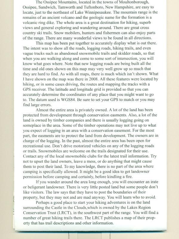
In case some have not seen the entire TB Map, I enclose the text, which I think shows the care that was taken to prevent landowner anger, and to promote proper use and good-will.

TBTEXT0001.jpg
 
IMO, the second to last paragraph was ill advised and unnecessarily adversarial. It doesn't appear to support your thesis that great care was taken to prevent landowner anger or promote good will.
 
Top