Comments invited on WMNF Kanc-7 Project

vftt.org

Help Support vftt.org:

This site may earn a commission from merchant affiliate links, including eBay, Amazon, and others.

psmart

Active member
Joined
Jan 27, 2007
Messages
558
Reaction score
48
Location
Chocorua, NH
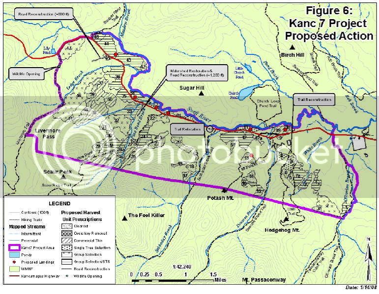
The WMNF has just published details of the proposed "Kanc-7" timber project. The project area is primarily on the south side of the Kanc, from the Olivarian Brook Trail to somewhat beyond the Pine Bend Brook Trail. If you are concerned about any of the trails in the area, or views of this area from the summits, I urge you to read the "scoping report" and submit comments within the official 30-day period, which began yesterday, January 17th.

This page provides a link to the 39-page PDF file. I urge you to print it out and devote some time to reviewing it in detail, especially the maps.

http://www.fs.fed.us/r9/forests/white_mountain/projects/projects/assessments/kanc_7/kanc_7.htm
 
Kanc-7 Details

Here is the map of the proposed cutting, as extracted from page 22 the PDF. (Sorry the resolution isn't that good, but that's all they included in the PDF)
Each number corresponds to a treatment unit, as shown in the legend. For example, there are four units along the UNH Trail, including a 7-acre clear-cut (unit 6) between the two branches of trail. The biggest impacts may be along the Pine Bend Brook Trail, with cutting on one or both sides of the trail all the way to the Wilderness boundary. There is also a 20-acre clear-cut (unit 13) along the Mt Potash Trail. (The red dots are new landings) Other units are not directly adjacent to trails, but the report identifies significant areas that will be visible from the summits.

Kanc7-Proposed.jpg


Here are the harvest methods as defined in the report:

Group Selection: small openings equal to or less than 2 acres, logically placed and treating up to 20 percent of a Unit.

STS: Single Tree Selection, an uneven age management system that retains a representation of existing species and ages of trees while reducing stand density to a specified square feet basal area.

CC: Clearcut, a cut method that removes all trees except reserve patches and creates an opening for regeneration of new trees.

Thin: Thinning a stand by removing smaller trees, damaged trees and low value or short lived trees to a specified square feet of basal area.
 
I printed that map yesterday and took it along with me. It looks like the most action is between Pine Bend Brook and Ledge Brook. I really love this area for bushwacking. I'm heading up there now to poke around a bit. Good and cold for snowshoeing today.

Tonight, I'll hit the lazy boy with the whole text after the game.

happy trails :)
 
Let us know what you see...

forestgnome said:
I printed that map yesterday and took it along with me. It looks like the most action is between Pine Bend Brook and Ledge Brook. I really love this area for bushwacking. I'm heading up there now to poke around a bit. Good and cold for snowshoeing today.

'gnome, let us know what you find. I would love to comment, but I would rather comment based in part on the ground view from someone I trust.

Thanks much!
 
For some reason right now the whole FS website is not loading for me, but I have a question based on the map you posted from them. Am I to understand correctly they are clearcutting right across the Sabbaday Brook, Potash Mt. and Hedgehog trails!? Or is this a selective cut (not that I find either appealing, but a slective cut is at least not as ugly)?

Brian
 
NewHampshire said:
Am I to understand correctly they are clearcutting right across the Sabbaday Brook, Potash Mt. and Hedgehog trails!? Or is this a selective cut
The WMNF rarely does clearcuts, they just do "group selection" where all the trees in an area are selected for cutting :)

I'm sure there will be a buffer preserved along the trail but the cutting area will be visible particularly in winter so you may see a different type of wildlife
 
RoySwkr said:
The WMNF rarely does clearcuts, they just do "group selection" where all the trees in an area are selected for cutting :)

I'm sure there will be a buffer preserved along the trail but the cutting area will be visible particularly in winter so you may see a different type of wildlife

Ok, I gotcha. I noticed last weekend heading up Hale Brook trail that the cutting they were doing off Zealand road last year was clearly visible from the trail. It looked like, at points, the edge of the cut came to within 25 yards of the trail. I found it a little annoying, but I guess thats the price we pay for "Labd of Many Uses".

Brian
 
NewHampshire said:
It looked like, at points, the edge of the cut came to within 25 yards of the trail. I found it a little annoying, but I guess thats the price we pay for "Labd of Many Uses".

Brian

If people think managed timber cutting like this is ugly and annoying.
They should see the outright devistation of illegal cutting in places like Brazil to provide us with cheap "disposable" plywood. Or the multi hectare clear cuts in the old growth siberian forest so we can have 2x4's to fuel our insatiable needs

Lou
 
Thanks for the "heads up" about the Kanc.
I must admit I used to get more shook up about the cuts in the WMNF a few years ago...nowadays the cuts seem so small compared to what I see up in Canada that I've become abit indifferent to them in the Whites.
They seem so tiny.

Still it's good that people keep an eye on what's going on so that they don't
get to the massive propotions of days gone by.

Working as a carpenter a few years back, I took a course on forestry...it seemed logical that I would want to know where the wood I was working with came from and the differnt thoughts on forest management etc...

I was duly impressed when I realized how much effort is put into the "view shed" of a particular cut up there.
What an area looks like from various angles of visibility from other mnts, rest areas, scenic vistas etc.

Pretty interesting all in all
 
Last edited:
NewHampshire said:
Am I to understand correctly they are clearcutting right across the Sabbaday Brook, Potash Mt. and Hedgehog trails!?

The proposal states: "Several of the proposed treatment areas lie immediately adjacent to existing hiking and nordic ski trails".

There is no mention of set-backs from the trails. Although cutting is sometimes set back from the trail, there have been many cases where the cutting is right up to the trail. The FS often claims this is done to enhance "visual qualities" (create a view). But it also tends to increase water problems in the trail as well as accelerated growth of brush. And in a few years you'll be looking at a wall of brush instead of the woods.
 
We were on the Hedgehog Trail yesterday and there was orange and blue flagging all around the trail on the lower sections. LarryD mentioned he thought it could be for logging- sounds like it could be true.
 
psmart said:
"..... And in a few years you'll be looking at a wall of brush instead of the woods.

I have often wondered how important a "view" is from the trail.
We often love to see the view but sometimes you can't see the "forest for all the trees" .

To me a wall of brush is a positive thing, good wildlife habitat and bio-diversity, for example.
However, how it might relate to water runoff by cutting to close to a trail would be a negative thing.
Seems there's always two sides to the coin...and around and around it goes.

Always looking for a happy medium...if there is ever such a thing.
 
Not that I really care for large scale logging but I have to remind my self that the WMNF is a multi-use foreset and the harvesting of lumber is one of those uses.

The amount of clear cutting I have seen in New England is relatively small compared to what I have seen down here in Georgia and South Carolina.
 
brianW said:
The amount of clear cutting I have seen in New England is relatively small compared to what I have seen down here in Georgia and South Carolina.
I think this is a remnant of the old days that caused the WMNF to be conceived. The Society for the Protection of NH Forests became a sort of "watchdog" group for responsible logging. I can't actually comment about the attitude towards logging down south, but I think up here the grotesque devastation the loggers did burned a long running dislike of "large scale" logging.

Brian
 
What I have learned through educational programs about logging down here is that there is a 3 to 4 part method of logging over a period of time.

The first cut it designed to get rid of undesirable species, diseased trees and trees that are not growing "right". This cut aloows the remaining tree to have more light, nutrients and water. Those allowing them to grow faster and larger.

Second cut is a few years (4-10) later and again trees are cut leaving the best and strongest to continue to grow. There may be a third cut again leaving the strongest best speciemens to grow. However some may be cut.

The last cut is usally a clear cut with the forest replanted. The firts two cuts the wood is ussaly for pulp and post wood (think fences) The most last two are for lumber and hopefully telephone poles (which bring the most $)

State and other agencies also use fire a lot to control the amount of fuel on the forest floor. The southern pine forest are naturally dependent to fire. During the spring time it is very common to see control fires burning in the distance. I also see many "blacked" tree trunks were I go mt. biking down here.
 
Top