Jazzbo
Well-known member
- Joined
- Jan 1, 2005
- Messages
- 1,197
- Reaction score
- 163
Mt Flume via Old and New Osseo Trails
One more hiking obsession vanquished! Lately I’ve been accomplishing hiking goals that have been obsessing me. I’ve been bugging my hiking friends for years with suggestions and requests to hike the Old Osseo Trail. Mike S consented to join me last Saturday on my quest to traverse the Old Osseo Trail. I first got it in my head to attempt this back in 2007. The first time was from the north end, but being an AMC trip it was quickly abandoned. The second time I attempted it solo and had to turn back due to lack of time. The third time proved to be the charm although by no means an easy charm.
The old Osseo Trail begins from a western most switchback turn on Clear Brook Road in Clear Brook Condos. Turn left when you come to a fork shortly after entering the condos and follow the road as it slabs up the slope. The trail begins at 1240’ elevation. From my study of the map the existing road appears to follow the original route of the trail. The trail shortly crosses Clear Brook and follows Clear Brook at a gentle grade until it reaches a point where three drainages come together at 1600’ elevation.
The trail crosses the main brook and begins to ascend more steeply as it follows the valley of the right hand drainage. The trail passes through a blow-down patch of very large trees. Side branches have been cut to ease passage, but that’s all. One of the big blow-downs has a yellow blaze indicating the trail passes under it.
After short time, the trail turns and directly attacks a very steep slope. We lost the trail at one point but quickly found it again. The trail has a definite treadway. The steep section blessedly tops out at 2600’ and trends eastward at gentle grade giving you a chance to catch your breath after a tough climb. Was this a regular trail, this steep section would quickly erode, but is fine as a bootleg trail. The trail crosses a slide and continues eastward until it turns northward into the 2800’ col between spur ridge and the main peak of Whaleback.
The trail now turns westward along a well defined trail into spruce-fir forest with occasional blow-downs. We tossed most of the lightweight variety blow-downs off trail. The trail then makes a series of short switchbacks as it climbs up and over the steep forehead of Whaleback. The spruce is scrubby here and gives glimpses of Loon Mountain across the valley. The trail becomes scrambly as trail tops out. The trail passes a nice outlook ledge at 3540’ where we stop for lunch and rest. This is 2300’ of elevation gain from our starting point.
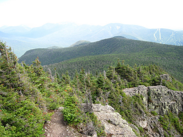
The view of Loon Mountain ski slopes and big slabs of twin slides on Scar Ridge glisten in the noon day sun.
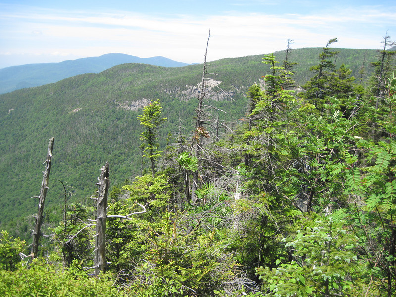
We’re rewarded with nice views of cliffs that ring the Clear Brook Ravine. This is a remarkable rugged ravine.
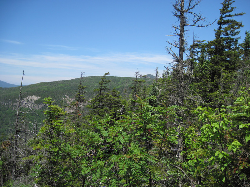
In this view you can see Mt Flume peaking over the plateau.
We resume the next leg of our journey. The trail now winds through spruce forest and passes close to the edge of some cliffs that offer a view of the Hitchcock’s and other peaks to the east. We now encounter our first in a long series of closely spaced blow-down patches. We lose the trail in process of attempting bypass one massive patch. We head in a particular direction which we think will take us back to the trail. We stop to rest and refuel and check our bearings before we get too far off course. The GPS tells us the trail is just a bit to the east. We head east and sure enough there it is. I’ll say here Garmin maps shows the Old Osseo Trail, but the actual trail on the ground differs markedly in some areas. In this area it was fairly accurate.
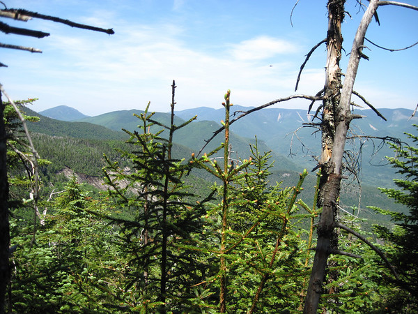
The blow-downs seem to last maybe a ½ mile or so, but it’s hard to tell. The constant gymnastics of negotiating these really kicked our butts. Doing this as an out & back hike was out of the question. The blow-down frequency and complexity seemed to diminish as we worked our way up the 3800’ knob. The trail becomes tolerable again as we passed by cliffs giving views of Flume getting closer
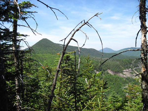
And some nice cliffs on the spur ridge followed by the new Osseo Trail, Owls Head, and the Bonds.
The last ½ mile of trail turned out to be downright easy. Someone is taking care of this end. We hooked up with the new Osseo and headed toward Mount Flume. We made it to the summit and were rewarded with pretty nice although hazy views. Bond Cliff was pretty well lit although not well enough to make for good photography. Better photagraphers than I have made pictures from this peak. I like this one because it shows Whaleback peaking up over the plateau, the starting point of our little adventure:
We lingered for 30 minutes and began the 5.6 mile hike to Lincoln Woods Trailhead via the new Osseo Trail. This was a long day. We spent 9.5 hours on the trail for a 10 mile hike. Back at Lincoln Woods I proceeded to cross the bridge over the East Branch where I proceeded to hitchhike back to Clear Brook Condos. I was picked up by a hiker whom we’d met on the trail. I picked up Mike and we headed home after a brief stop at Mountain Wanderer in Lincoln.
Is this a bush whack hike or not? The trail is blazed with yellow blazes along its entire length. The first 2.25 miles is simply a bootleg trail. The ½ mile or more of trail through the blow-down terrain is not at all obvious or easy to follow even with the blazes. This section has been flagged as well. You could get into serious trouble on the somewhat featureless plateau if you got too far off trail. The blow-downs are relentless and trail is overgrown so it is exhausting. I wouldn’t recommend it unless you’re ok with off-trail navigation and with hard work of climbing over, under, and around thick blow-downs and muscling through spruce. The trail is still there to be found, but in addition to blow-downs, this section has grown in a lot so it’s very tricky to follow.
Is someone or somebody maintaining this trail? Nibbling away at both ends is more accurate description. It would take days for a big well-equipped crew to brush the blow-down section to make it easier to follow and is unlikely one or two individuals will ever be able to pull off in their spare time. Meanwhile bootleg trail to Whaleback is nice and Whaleback and the Clear Brook Ravine is an impressive area of terrain in its own right and is worth of a visit if you like that sort of thing. Seems to be a lot of good wild rock climbing terrain located close to town.
One more hiking obsession vanquished! Lately I’ve been accomplishing hiking goals that have been obsessing me. I’ve been bugging my hiking friends for years with suggestions and requests to hike the Old Osseo Trail. Mike S consented to join me last Saturday on my quest to traverse the Old Osseo Trail. I first got it in my head to attempt this back in 2007. The first time was from the north end, but being an AMC trip it was quickly abandoned. The second time I attempted it solo and had to turn back due to lack of time. The third time proved to be the charm although by no means an easy charm.
The old Osseo Trail begins from a western most switchback turn on Clear Brook Road in Clear Brook Condos. Turn left when you come to a fork shortly after entering the condos and follow the road as it slabs up the slope. The trail begins at 1240’ elevation. From my study of the map the existing road appears to follow the original route of the trail. The trail shortly crosses Clear Brook and follows Clear Brook at a gentle grade until it reaches a point where three drainages come together at 1600’ elevation.
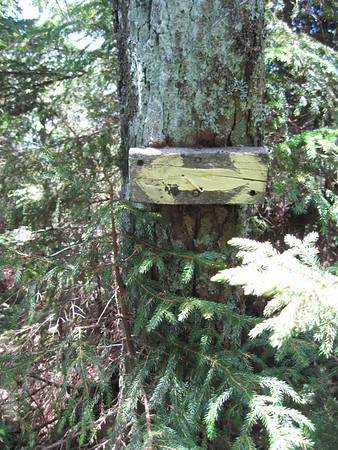
The trail crosses the main brook and begins to ascend more steeply as it follows the valley of the right hand drainage. The trail passes through a blow-down patch of very large trees. Side branches have been cut to ease passage, but that’s all. One of the big blow-downs has a yellow blaze indicating the trail passes under it.
After short time, the trail turns and directly attacks a very steep slope. We lost the trail at one point but quickly found it again. The trail has a definite treadway. The steep section blessedly tops out at 2600’ and trends eastward at gentle grade giving you a chance to catch your breath after a tough climb. Was this a regular trail, this steep section would quickly erode, but is fine as a bootleg trail. The trail crosses a slide and continues eastward until it turns northward into the 2800’ col between spur ridge and the main peak of Whaleback.
The trail now turns westward along a well defined trail into spruce-fir forest with occasional blow-downs. We tossed most of the lightweight variety blow-downs off trail. The trail then makes a series of short switchbacks as it climbs up and over the steep forehead of Whaleback. The spruce is scrubby here and gives glimpses of Loon Mountain across the valley. The trail becomes scrambly as trail tops out. The trail passes a nice outlook ledge at 3540’ where we stop for lunch and rest. This is 2300’ of elevation gain from our starting point.
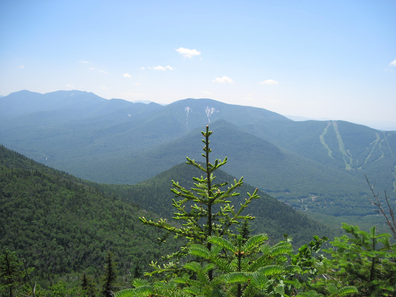
The view of Loon Mountain ski slopes and big slabs of twin slides on Scar Ridge glisten in the noon day sun.
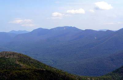
We’re rewarded with nice views of cliffs that ring the Clear Brook Ravine. This is a remarkable rugged ravine.
In this view you can see Mt Flume peaking over the plateau.
We resume the next leg of our journey. The trail now winds through spruce forest and passes close to the edge of some cliffs that offer a view of the Hitchcock’s and other peaks to the east. We now encounter our first in a long series of closely spaced blow-down patches. We lose the trail in process of attempting bypass one massive patch. We head in a particular direction which we think will take us back to the trail. We stop to rest and refuel and check our bearings before we get too far off course. The GPS tells us the trail is just a bit to the east. We head east and sure enough there it is. I’ll say here Garmin maps shows the Old Osseo Trail, but the actual trail on the ground differs markedly in some areas. In this area it was fairly accurate.
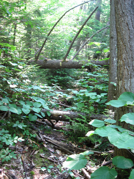
The blow-downs seem to last maybe a ½ mile or so, but it’s hard to tell. The constant gymnastics of negotiating these really kicked our butts. Doing this as an out & back hike was out of the question. The blow-down frequency and complexity seemed to diminish as we worked our way up the 3800’ knob. The trail becomes tolerable again as we passed by cliffs giving views of Flume getting closer
And some nice cliffs on the spur ridge followed by the new Osseo Trail, Owls Head, and the Bonds.
The last ½ mile of trail turned out to be downright easy. Someone is taking care of this end. We hooked up with the new Osseo and headed toward Mount Flume. We made it to the summit and were rewarded with pretty nice although hazy views. Bond Cliff was pretty well lit although not well enough to make for good photography. Better photagraphers than I have made pictures from this peak. I like this one because it shows Whaleback peaking up over the plateau, the starting point of our little adventure:
We lingered for 30 minutes and began the 5.6 mile hike to Lincoln Woods Trailhead via the new Osseo Trail. This was a long day. We spent 9.5 hours on the trail for a 10 mile hike. Back at Lincoln Woods I proceeded to cross the bridge over the East Branch where I proceeded to hitchhike back to Clear Brook Condos. I was picked up by a hiker whom we’d met on the trail. I picked up Mike and we headed home after a brief stop at Mountain Wanderer in Lincoln.
Is this a bush whack hike or not? The trail is blazed with yellow blazes along its entire length. The first 2.25 miles is simply a bootleg trail. The ½ mile or more of trail through the blow-down terrain is not at all obvious or easy to follow even with the blazes. This section has been flagged as well. You could get into serious trouble on the somewhat featureless plateau if you got too far off trail. The blow-downs are relentless and trail is overgrown so it is exhausting. I wouldn’t recommend it unless you’re ok with off-trail navigation and with hard work of climbing over, under, and around thick blow-downs and muscling through spruce. The trail is still there to be found, but in addition to blow-downs, this section has grown in a lot so it’s very tricky to follow.
Is someone or somebody maintaining this trail? Nibbling away at both ends is more accurate description. It would take days for a big well-equipped crew to brush the blow-down section to make it easier to follow and is unlikely one or two individuals will ever be able to pull off in their spare time. Meanwhile bootleg trail to Whaleback is nice and Whaleback and the Clear Brook Ravine is an impressive area of terrain in its own right and is worth of a visit if you like that sort of thing. Seems to be a lot of good wild rock climbing terrain located close to town.