buckyball1
New member
One of my daughters works at Reed College in Portland, OR and I try to visit her once a year and usually throw in a solo hiking road trip. Last year the hikes included South Sister near Bend (superb hike), but no TRs as for reasons still not clear to me i took a 2 month hiatus from hiking upon my return; thought i might "quit" altogether. Fortunately the pull of the woods istoo strong.
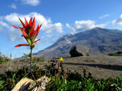
This year, the highlight of my hiking was Mt St Helens. There's a permit system to climb St Helens by the "tourist" route, south side, Monitor Ridge, about 9.5 miles RT and a bit over 4600' ascent. The 100 permits per day go quickly after 2/1 and due to injury and indecision i found myself with no permit come July. I was fortunate to get one at cost on the Cascade Climbers Permit exchange site.
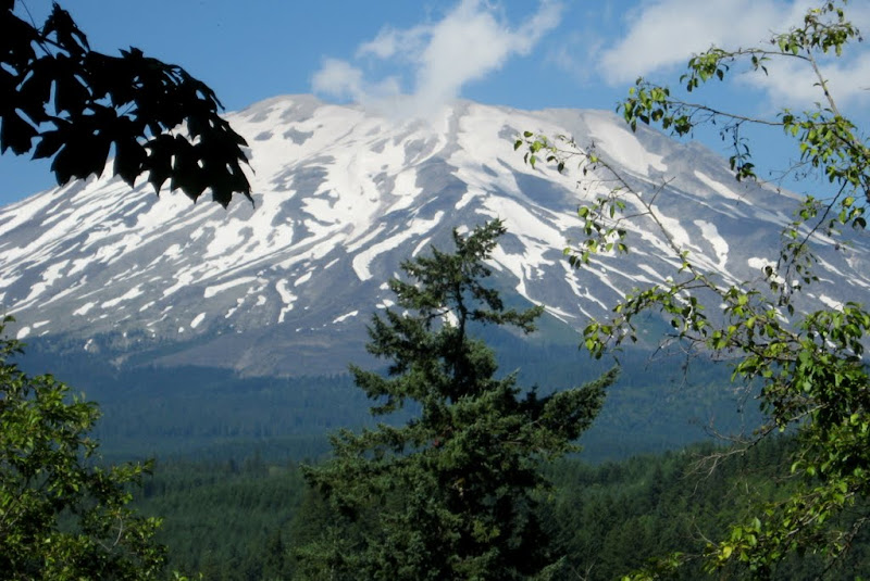
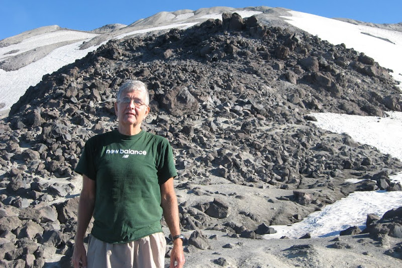
On 8/19 I drove to WA from Portland on Rt 5 and cut east toward the south side of St Helens through Cougar where i picked up my permit and signed in for the hike at Lone Fir Lodge, a very commercial campground. Drove a series of good USFS roads to the Climbers Bivouac at the base of St Helens (3700')-parking, utilitarian camp sites. On the way up, I got my first look at the mountain and the heavy snow load in place throughout the Northwest. Much more snow than when i climbed in early August 2010.
St Helens
I probably overreact, but i'm starting to feel "ageism" during the usual banter/sizing up that goes on at a place like the Climbers Bivouac the night before the hike. One 20 something smirked when i asked about any "bear problem" (meaning at campsite re food) and assured me that the bears would not get after me on the hike, then allowed how this was a pretty stiff hike and that "many people have problems summitting".
Slept well, off about 550AM following 2 women who left around 430. The hike can be broken into 3 parts; a 2+ mile moderate uphill on a great trail, a tough 2.7 mile leg up the lava boulder strewn Monitor Ridge followed by less than a mile up a very steep ash/cinder slope to the rim. There are snow chutes (the adventurous glissade down some) surrounding much of the route.
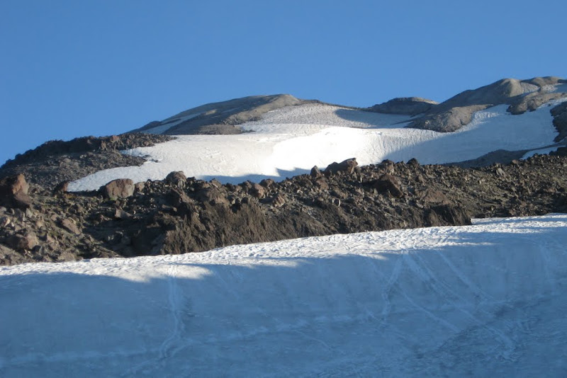
typical snow fields and minor ridges adjacent to Monitor Ridge
The first two miles were a pleasant uphill stroll through the woods on a typically great western trail, wide/smooth. Then hit the long Monitor Ridge which for me was the toughest part of the hike; sharp lava boulders mixed with patches of ash and skree on a moderately steep ridge with steep "steps" and no clear path other than wend your way from one large post to the next-trickier with nobody to follow.
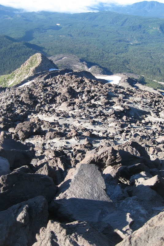
looking down the Monitor Ridge
I finally reached the instrument filled monitoring site at the top of the ridge named for it and stopped to rest and refuel with 3 younger hikers whom i'd been playing leapfrog with ascending the ridge. They asked me to join them going up the cinder/skree steeps and since they were local, experienced and nice guys (one has climbed Hood, Ranier, Baker, etc and this was his 8th time up St Helens) i was happy to (no idea what to expect for snow/cornices on the rim).
looking up the cinder slope toward the rim
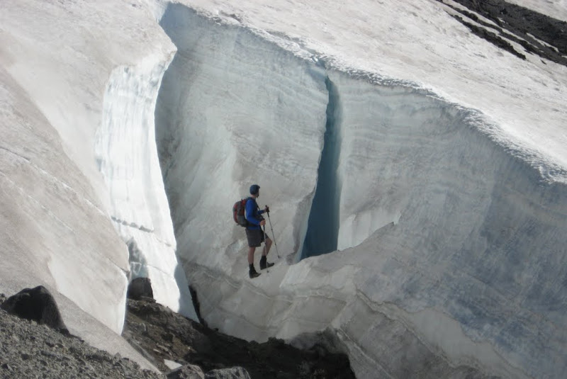
I gaped in amazement as the glaciated peak guy as i called him wandered in the deep snow chutes/crevasses beside the trail as we ascended (no traction devices-yike!)
my friend wandering around-he actually went into this one
We slogged up the cinder slope, tacking back and forth, sliding backward less than the beta would suggest, but man, it was a calf burner, 1300'+ in about 0.7 miles-full sun was boiling by now, hottest days of the summer out there. We reached the rim of the crater to find the two "early" hikers had arrived shortly before us-the 6 of us had the place to ourselves for over 1/2 hour before i started down.
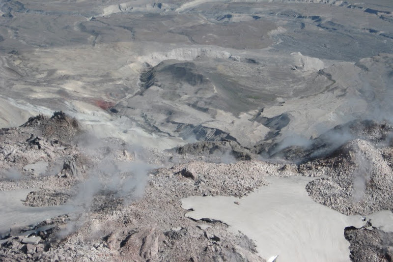
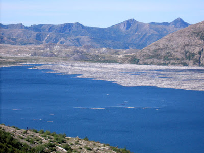
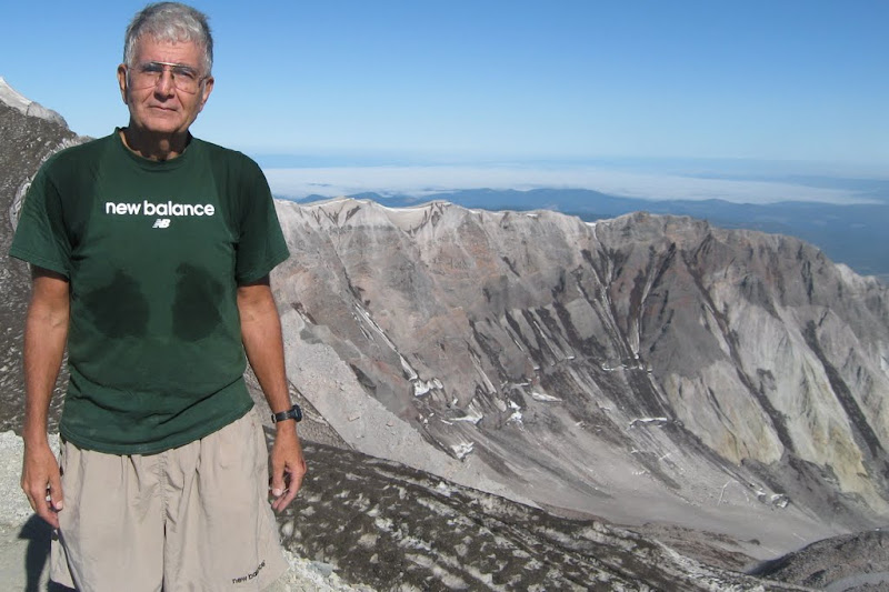
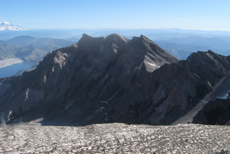
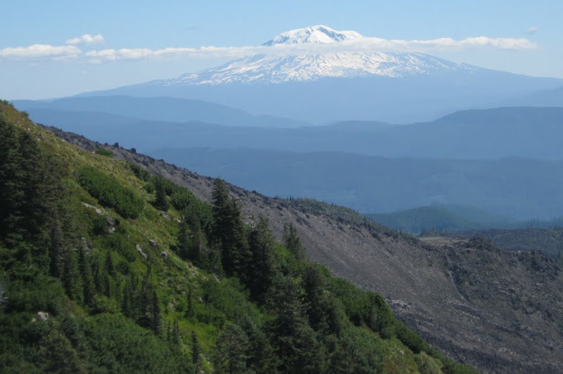
Wow, what a panorama. We wandered a bit counterclockwise on the rim to a spot marginally higher than what the guys said was the official finish/stop where we topped out-soon hit snow and a cornice and on the advice of my "snow/ice experienced" companion decided not to go any further for safety's sake. The views from the rim were breathtaking. Hood to the south, Adams to the east, Ranier to the north, the jagged, blasted open crater walls stretching in both directions, the deep multicolored, steaming crater and Spirit Lake still filled with trees from the blast.
"top"/west rim
snow/ice near rim, east rim, Spirit Lake (logs, not ice)
Ranier
I was loath to leave such a place, but finally headed down-long slog on the rocks compared to my new friends who glissaded some of the snow chutes-they said it was crazy late in the year to be able to do that. Soon hit the trail of ants wending their way up the mountain-maybe 70-80 people on the mountain that day and i'm guessing maybe 1/2 made it up? Never saw so many ice axes that must have had the price tags still on them") . Near the monitoring station, i passed the guy from the night before who thought i'd not make it and while gasping he actually asked "did you get to the top?"-just smiled and said "of course".
. Near the monitoring station, i passed the guy from the night before who thought i'd not make it and while gasping he actually asked "did you get to the top?"-just smiled and said "of course".
Excellent, challenging, hi reward hike. I'd say harder than Washington from "easier" approaches (maybe not the Gulf) and easier than South Sister (which is my fav NW hike to date)....so glad i did this.
---you probably thought i only hike 1800' totally wooded peaks in Aroostook County---
Fun small/big hikes later in week (maybe another TR or so?-cool places) and then stuck 5 extra days in Portland as flights disrupted by Irene. There are much worse places to be-were i younger, i'd surely consider leaving the east for the NW--very different, tolerant, laid back vibe
-thanks Kevin Rooney
jim
This year, the highlight of my hiking was Mt St Helens. There's a permit system to climb St Helens by the "tourist" route, south side, Monitor Ridge, about 9.5 miles RT and a bit over 4600' ascent. The 100 permits per day go quickly after 2/1 and due to injury and indecision i found myself with no permit come July. I was fortunate to get one at cost on the Cascade Climbers Permit exchange site.
On 8/19 I drove to WA from Portland on Rt 5 and cut east toward the south side of St Helens through Cougar where i picked up my permit and signed in for the hike at Lone Fir Lodge, a very commercial campground. Drove a series of good USFS roads to the Climbers Bivouac at the base of St Helens (3700')-parking, utilitarian camp sites. On the way up, I got my first look at the mountain and the heavy snow load in place throughout the Northwest. Much more snow than when i climbed in early August 2010.
St Helens
I probably overreact, but i'm starting to feel "ageism" during the usual banter/sizing up that goes on at a place like the Climbers Bivouac the night before the hike. One 20 something smirked when i asked about any "bear problem" (meaning at campsite re food) and assured me that the bears would not get after me on the hike, then allowed how this was a pretty stiff hike and that "many people have problems summitting".
Slept well, off about 550AM following 2 women who left around 430. The hike can be broken into 3 parts; a 2+ mile moderate uphill on a great trail, a tough 2.7 mile leg up the lava boulder strewn Monitor Ridge followed by less than a mile up a very steep ash/cinder slope to the rim. There are snow chutes (the adventurous glissade down some) surrounding much of the route.
typical snow fields and minor ridges adjacent to Monitor Ridge
The first two miles were a pleasant uphill stroll through the woods on a typically great western trail, wide/smooth. Then hit the long Monitor Ridge which for me was the toughest part of the hike; sharp lava boulders mixed with patches of ash and skree on a moderately steep ridge with steep "steps" and no clear path other than wend your way from one large post to the next-trickier with nobody to follow.
looking down the Monitor Ridge
I finally reached the instrument filled monitoring site at the top of the ridge named for it and stopped to rest and refuel with 3 younger hikers whom i'd been playing leapfrog with ascending the ridge. They asked me to join them going up the cinder/skree steeps and since they were local, experienced and nice guys (one has climbed Hood, Ranier, Baker, etc and this was his 8th time up St Helens) i was happy to (no idea what to expect for snow/cornices on the rim).
looking up the cinder slope toward the rim
I gaped in amazement as the glaciated peak guy as i called him wandered in the deep snow chutes/crevasses beside the trail as we ascended (no traction devices-yike!)
my friend wandering around-he actually went into this one
We slogged up the cinder slope, tacking back and forth, sliding backward less than the beta would suggest, but man, it was a calf burner, 1300'+ in about 0.7 miles-full sun was boiling by now, hottest days of the summer out there. We reached the rim of the crater to find the two "early" hikers had arrived shortly before us-the 6 of us had the place to ourselves for over 1/2 hour before i started down.
Wow, what a panorama. We wandered a bit counterclockwise on the rim to a spot marginally higher than what the guys said was the official finish/stop where we topped out-soon hit snow and a cornice and on the advice of my "snow/ice experienced" companion decided not to go any further for safety's sake. The views from the rim were breathtaking. Hood to the south, Adams to the east, Ranier to the north, the jagged, blasted open crater walls stretching in both directions, the deep multicolored, steaming crater and Spirit Lake still filled with trees from the blast.
"top"/west rim
snow/ice near rim, east rim, Spirit Lake (logs, not ice)
Ranier
I was loath to leave such a place, but finally headed down-long slog on the rocks compared to my new friends who glissaded some of the snow chutes-they said it was crazy late in the year to be able to do that. Soon hit the trail of ants wending their way up the mountain-maybe 70-80 people on the mountain that day and i'm guessing maybe 1/2 made it up? Never saw so many ice axes that must have had the price tags still on them
. Near the monitoring station, i passed the guy from the night before who thought i'd not make it and while gasping he actually asked "did you get to the top?"-just smiled and said "of course".Excellent, challenging, hi reward hike. I'd say harder than Washington from "easier" approaches (maybe not the Gulf) and easier than South Sister (which is my fav NW hike to date)....so glad i did this.
---you probably thought i only hike 1800' totally wooded peaks in Aroostook County
---Fun small/big hikes later in week (maybe another TR or so?-cool places) and then stuck 5 extra days in Portland as flights disrupted by Irene. There are much worse places to be-were i younger, i'd surely consider leaving the east for the NW--very different, tolerant, laid back vibe
-thanks Kevin Rooney
jim
Last edited: