una_dogger
Well-known member
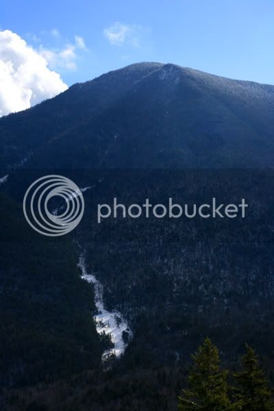
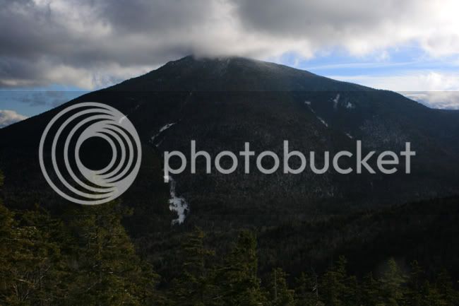
Whiteface, elev. 4020
NH48 #39
NE67 # 53
NEHH #62
NE115 #100
The trip in a nutshell:
Jason, Leaf and I met up in N Lincoln friday night, our plans for a Bonds Traverse the following day dashed by the incoming weather conditions. We opted to climb Whiteface and Passaconnaway from the Kanc, up Downes Brook Tr and down Oliverian Brook Tr was the plan.
We drove over the Kanc Pass during a spectacular sunrise, spotted Jason's car at the Oliverian Brook TH, then drove to our starting TH. We hit the trail at 7:00 am and enjoyed a packed and broken out trail for the first ~3/4 mile of the Downes Brook Trail. The sun rose over Hedgehog Mnt as we hiked along and Leaf and I were happy, because, well, we haven't seen the sun in a while in the Greater Boston area!
Not having been in the area before, all we knew was that we'd be following the brook for about four miles until we met up with The Kate Sleeper Trail, and that there are generally ten spots along the trail where the brook is crossed. The broken out trail ended near a campsite where a sleepy looking camper was stirring about camp. From here we broke trail. Having no blazes to follow, we crossed where the grades seemed to naturally infer "cross here". There was about 8 inches of light powder on top of a very consolidated snowpack of about five-six feet. The breaking was easy for us, and I was glad because Leaf was shlepping two gallons of water in a training effort for her upcoming trip to Denali. (Go Leaf!)
The brook crossings were tricky and required concentration and a light foot. The snowbank caved in once when I crossed, and my left snowshoe and foot went down into the water. I was able to get up and out quickly without dislodging any more of the bank, and once again my Merrell Thermo 8 boots kept me dry and warm.")
We reached a point 2.5 miles in where the brook divided in many areas. Not sure which branch to follow, we first went to the right in the steepest part of the divide. Jason began to cross, and freed a huge chunk of snowbank. The water was flowing deeply, even here at elevation 2300 feet. Jason was happy to be wearing his La Sportiva modified plastics, and he also stayed warm and dry. We aborted and moved to the East (left) side of the watershed. Here we continued to follow a branch of the brook, tediously moving along the banks. We climbed about 100 feet higher on the slope and followed the contour. Coming down from Passaconnaway's slopes on our left was the end of the small slide Rocksnrolls, MichaelJ and I had crossed up high a few weeks ago on the Passaconnaway Cutoff Trail. Its neat to "connect the dots" on the landscape, and I smiled and took a way point. I remembered thinking up high, "I wonder where this slide bottoms out". Now I knew.
Moving forward we hit a steep wall, and decided to push to the West (right) side of the watershed, where a finger of land was forming a ridge. We climbed to the top of the small ridge, where the woods were open and we could get a better view of the watershed in its entirety and consider our next move. Once on the ridge, we pulled our maps, my GPS and Jason's compass. At this point, we decided this was gonna be a 'whack of Whiteface!!! Yeehaw! We climbed the ridge that we dubbed, "The Devil's Finger". We began our bushwack at elevation 2362ft and climbed up along the ridge for approximately 1.4 miles before topping out on a false summit on the northern end of Whiteface at elevation 3735ft.
The woods were mixed, spruce and yellow birch. The snowpack was deep and consolidated, making the breaking as easy as it was on the trail. We climbed up the contours making a southeasterly sweep, sometimes leveling and following the contour, other times climbing. We reached an open and fairly exposed area at 2882 ft and chose to push upward. We were aiming for the Rollins Trail in a saddle about 1/3 mile south of Whiteface's summit, but had to cut up and east. (later we saw why the slope got so steep there...stay tuned).
Jason and Leaf, the ridge is nice and open

And then....the spruce got thick. The temperatures were steady all day in the upper 20's, getting warmer as the afternoon went on, a good thing, because we were getting wet. As we pushed upward, we encountered ledges that we circumnavigated or climbed, depending on the availability of good trees to hug. Finally, some sunlight broke and a good sized headwall stood out in front of us. Jason was ahead of us and scrambled up first, there was a perfectly placed spruce to hug, climb up, and park your butt on and one by one we scaled the wall. Little Terra Firma just bee-bopped up it with a big smile on her face.
Wow. What a view. Passaconnay to our our left. Big mountain that Passaconnaway, I seem to never get much closer than this to it on both this and my recent attempt. It was awesome to see it, and The Sleepers and The Fool Killer from this perspective. The Tripyramids beyond had their summits obscured in heavy cloud cover. We were on a small northern summit of Whiteface, and we felt awesome! Woot! Now to get to the Rollins Trail or the true summit, whichever came first. Deeeeeep spruce up there. Definately spruce trap territory but we moved carefully and close together as we had all day, and we didn't find any. We kept moving south but then bumbled a bit and got turned north for about five steps as we began to drop a bit and once again the maps, compass and GPS came out and we took a little navigational pow-wow. Quickly we corrected, dropped south, and bingo! The Rollins Trail, and it was broken out, and it was 13:15. Nice progress!
West from "North Whiteface"

We were about 3/4 mile from the Whiteface Summit and after pulling off wet hardshells and getting into warm fleeces and softshells, we pushed on. I have done about three bushwacks prior to this one and I collectively feel really ready to find the trail towards the end and then sooo happy to be on one when its found. Today was no different, but I definately felt my confidence has increased with each 'whack; and today I was especially proud of the efforts of our little rag tag group. Frequent communication, clear decision making, mutual respect for the skill level each member brought with them, and supportive concern for each member made this challenge a pleasure and a complete success. Thanks, guys!
Jason leads, watching out for Spruce Traps (out of sequence, below headwall on N Summit)

We summitted Whiteface and decided we would head back down to Downe's Brook, leaving Passaconnaway for another day. A couple of reasons, we were getting tired, we had gotten wet, and we really wanted to close our loop and see what we had wacked up.
The Kate Sleeper Trail was not broken out but was blazed and easy to follow. Soon we came to the Downe's Brook Tr junction, and began working our way down this rugged watershed. Many, many tedious crossings and we are not sure if we were ever on the "true trail" but carefully picked our route to keep us out of the water. Huge boulders make up the brook which was flowing strong at its origin, and deepend as it flowed downslope as brooks will do...with this being winter, it was interesting to observe so much water.
I eluded to a steep open spot on our bushwack. We knew the Downe's Slide was in the general area, but we were *amazed* when we were coming down the Downe's Brook Tr and saw it careening down from the ridge we'd wacked. Pretty wide slide. Interesting how our day had unfolded, how we'd picked our line up the ridge, and had managed to avoid the slide, prolly crossing turning east and up somewhere just above the top of the slide. (if anyone has any waypoints on the origin of the slide, please pm me, I'd love to add it to my tracklog.) Way cool. Wacking is fun. This was Leaf's first bushwack! I told her, "<quote> 'there are two states of being..on trail...and off trail'...I said that! <end quote>". We all laughed. Then refocused our attention on negotiating the brook, often climbing small "fingers" of land to avoid it.
After what felt like more than an hour on the Downe's Brook Trail we saw our initial tracks diverging off to the east, we had closed the loop! (well, sorta, we still had to get to that side of the brook!). We stayed on this side of the brook, though, and found the "true trail". Some more tedious crossings and we were back on an easy grade. Hiking on we enjoyed some great conversation; some deep "life talk" and some reminiscent Catskill conversation. Jason has been 'wacking the untrailed peaks on the CAT3500 list this winter and really honing his skills with map and compass, and recently becoming the proud owner of a Garmin 60sxc (?).
The headlamps came on for the last mile, and we broke out of the woods at 6:15, about 11 hours and ~14 miles later. A snowy ride over the Kancamangus Pass, back to a warm hotel for dry clothes and dinner for Terra, then out to the Woodstock Inn for brews, food, and tunes.
A GREAT day out in the woods!
Thanks to Leaf and Jason !

edited to say, we all wished out loud that today's snowstorm will cover our tracks! Not sure too many would appreciate following our trail to Whiteface.
NH48 #39
NE67 # 53
NEHH #62
NE115 #100
The trip in a nutshell:
Jason, Leaf and I met up in N Lincoln friday night, our plans for a Bonds Traverse the following day dashed by the incoming weather conditions. We opted to climb Whiteface and Passaconnaway from the Kanc, up Downes Brook Tr and down Oliverian Brook Tr was the plan.
We drove over the Kanc Pass during a spectacular sunrise, spotted Jason's car at the Oliverian Brook TH, then drove to our starting TH. We hit the trail at 7:00 am and enjoyed a packed and broken out trail for the first ~3/4 mile of the Downes Brook Trail. The sun rose over Hedgehog Mnt as we hiked along and Leaf and I were happy, because, well, we haven't seen the sun in a while in the Greater Boston area!
Not having been in the area before, all we knew was that we'd be following the brook for about four miles until we met up with The Kate Sleeper Trail, and that there are generally ten spots along the trail where the brook is crossed. The broken out trail ended near a campsite where a sleepy looking camper was stirring about camp. From here we broke trail. Having no blazes to follow, we crossed where the grades seemed to naturally infer "cross here". There was about 8 inches of light powder on top of a very consolidated snowpack of about five-six feet. The breaking was easy for us, and I was glad because Leaf was shlepping two gallons of water in a training effort for her upcoming trip to Denali. (Go Leaf!)
The brook crossings were tricky and required concentration and a light foot. The snowbank caved in once when I crossed, and my left snowshoe and foot went down into the water. I was able to get up and out quickly without dislodging any more of the bank, and once again my Merrell Thermo 8 boots kept me dry and warm.
We reached a point 2.5 miles in where the brook divided in many areas. Not sure which branch to follow, we first went to the right in the steepest part of the divide. Jason began to cross, and freed a huge chunk of snowbank. The water was flowing deeply, even here at elevation 2300 feet. Jason was happy to be wearing his La Sportiva modified plastics, and he also stayed warm and dry. We aborted and moved to the East (left) side of the watershed. Here we continued to follow a branch of the brook, tediously moving along the banks. We climbed about 100 feet higher on the slope and followed the contour. Coming down from Passaconnaway's slopes on our left was the end of the small slide Rocksnrolls, MichaelJ and I had crossed up high a few weeks ago on the Passaconnaway Cutoff Trail. Its neat to "connect the dots" on the landscape, and I smiled and took a way point. I remembered thinking up high, "I wonder where this slide bottoms out". Now I knew.
Moving forward we hit a steep wall, and decided to push to the West (right) side of the watershed, where a finger of land was forming a ridge. We climbed to the top of the small ridge, where the woods were open and we could get a better view of the watershed in its entirety and consider our next move. Once on the ridge, we pulled our maps, my GPS and Jason's compass. At this point, we decided this was gonna be a 'whack of Whiteface!!! Yeehaw! We climbed the ridge that we dubbed, "The Devil's Finger". We began our bushwack at elevation 2362ft and climbed up along the ridge for approximately 1.4 miles before topping out on a false summit on the northern end of Whiteface at elevation 3735ft.
The woods were mixed, spruce and yellow birch. The snowpack was deep and consolidated, making the breaking as easy as it was on the trail. We climbed up the contours making a southeasterly sweep, sometimes leveling and following the contour, other times climbing. We reached an open and fairly exposed area at 2882 ft and chose to push upward. We were aiming for the Rollins Trail in a saddle about 1/3 mile south of Whiteface's summit, but had to cut up and east. (later we saw why the slope got so steep there...stay tuned).
Jason and Leaf, the ridge is nice and open
And then....the spruce got thick. The temperatures were steady all day in the upper 20's, getting warmer as the afternoon went on, a good thing, because we were getting wet. As we pushed upward, we encountered ledges that we circumnavigated or climbed, depending on the availability of good trees to hug. Finally, some sunlight broke and a good sized headwall stood out in front of us. Jason was ahead of us and scrambled up first, there was a perfectly placed spruce to hug, climb up, and park your butt on and one by one we scaled the wall. Little Terra Firma just bee-bopped up it with a big smile on her face.
Wow. What a view. Passaconnay to our our left. Big mountain that Passaconnaway, I seem to never get much closer than this to it on both this and my recent attempt. It was awesome to see it, and The Sleepers and The Fool Killer from this perspective. The Tripyramids beyond had their summits obscured in heavy cloud cover. We were on a small northern summit of Whiteface, and we felt awesome! Woot! Now to get to the Rollins Trail or the true summit, whichever came first. Deeeeeep spruce up there. Definately spruce trap territory but we moved carefully and close together as we had all day, and we didn't find any. We kept moving south but then bumbled a bit and got turned north for about five steps as we began to drop a bit and once again the maps, compass and GPS came out and we took a little navigational pow-wow. Quickly we corrected, dropped south, and bingo! The Rollins Trail, and it was broken out, and it was 13:15. Nice progress!
West from "North Whiteface"
We were about 3/4 mile from the Whiteface Summit and after pulling off wet hardshells and getting into warm fleeces and softshells, we pushed on. I have done about three bushwacks prior to this one and I collectively feel really ready to find the trail towards the end and then sooo happy to be on one when its found. Today was no different, but I definately felt my confidence has increased with each 'whack; and today I was especially proud of the efforts of our little rag tag group. Frequent communication, clear decision making, mutual respect for the skill level each member brought with them, and supportive concern for each member made this challenge a pleasure and a complete success. Thanks, guys!
Jason leads, watching out for Spruce Traps (out of sequence, below headwall on N Summit)
We summitted Whiteface and decided we would head back down to Downe's Brook, leaving Passaconnaway for another day. A couple of reasons, we were getting tired, we had gotten wet, and we really wanted to close our loop and see what we had wacked up.
The Kate Sleeper Trail was not broken out but was blazed and easy to follow. Soon we came to the Downe's Brook Tr junction, and began working our way down this rugged watershed. Many, many tedious crossings and we are not sure if we were ever on the "true trail" but carefully picked our route to keep us out of the water. Huge boulders make up the brook which was flowing strong at its origin, and deepend as it flowed downslope as brooks will do...with this being winter, it was interesting to observe so much water.
I eluded to a steep open spot on our bushwack. We knew the Downe's Slide was in the general area, but we were *amazed* when we were coming down the Downe's Brook Tr and saw it careening down from the ridge we'd wacked. Pretty wide slide. Interesting how our day had unfolded, how we'd picked our line up the ridge, and had managed to avoid the slide, prolly crossing turning east and up somewhere just above the top of the slide. (if anyone has any waypoints on the origin of the slide, please pm me, I'd love to add it to my tracklog.) Way cool. Wacking is fun. This was Leaf's first bushwack! I told her, "<quote> 'there are two states of being..on trail...and off trail'...I said that! <end quote>". We all laughed. Then refocused our attention on negotiating the brook, often climbing small "fingers" of land to avoid it.
After what felt like more than an hour on the Downe's Brook Trail we saw our initial tracks diverging off to the east, we had closed the loop! (well, sorta, we still had to get to that side of the brook!). We stayed on this side of the brook, though, and found the "true trail". Some more tedious crossings and we were back on an easy grade. Hiking on we enjoyed some great conversation; some deep "life talk" and some reminiscent Catskill conversation. Jason has been 'wacking the untrailed peaks on the CAT3500 list this winter and really honing his skills with map and compass, and recently becoming the proud owner of a Garmin 60sxc (?).
The headlamps came on for the last mile, and we broke out of the woods at 6:15, about 11 hours and ~14 miles later. A snowy ride over the Kancamangus Pass, back to a warm hotel for dry clothes and dinner for Terra, then out to the Woodstock Inn for brews, food, and tunes.
A GREAT day out in the woods!
Thanks to Leaf and Jason !
edited to say, we all wished out loud that today's snowstorm will cover our tracks! Not sure too many would appreciate following our trail to Whiteface.
Last edited: