
Damselfly
New member
Friends Mike LaRoss, Bill Magyar, and Lew Dow, new acquaintance Dennis, and I set out for Lowell and Anderson. For Mike and I... it was to be our NHHH finish.
With the Sawyer River Road still out from Hurricane Irene and the daylight short, three of us arrived Friday night and slept in our cars so that we could get some sleep. Up at 4am... breakfast... car shuttle to Nancy Pond Trail... we were on the trail in headlamps at 5:10.

Up at the junction of Signal Ridge Trail, we bushwhacked a short distance along the S side of Whiteface Brook to avoid the brook crossing and its icy rocks in the dark.
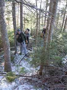
We started the whack at the junction with the Carrigain Notch Trail. Following a northerly line up the south ridge of Lowell, we traveled through mostly open woods for quite a while. The woods naturally became more moderate, but not tough, as we approached the summit. And it was only the last .3 mi. that was really steep and dense.

We arrived at the summit after about 3:25 of whacking. Just as promised, there was a view spot that had been cut, affording us really nice views to the east. It was cold and a long ways still to go... so we didn't stay long.

We headed north towards Anderson. The down slope of the land wanted to pull us a bit east, but we could always get glimpses of Anderson through the trees, so it was easy to stay on course.

The going was thick, and it took us almost 40 minutes to hit the col. From there, it was a steep climb up to Anderson. At one point about 2/3's of the way up the slope, we found a small piece of real estate that allowed the five of us to catch some sun and a water / snack break. We had only 440' left to climb, and only .2 mi. left to go... very steep and thick. It was our finish, so Mike and I led on. (With break, the trip through the col took us 1:45)
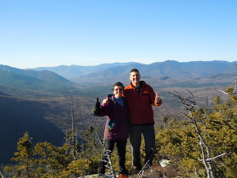
Finally the summit of Anderson! Joy! It's been a long journey to this point. Again, as promised... there were ledges just 15-20 yards south, with 240 degree views. Mike and I had our "Finish" photos taken here... and we lounged like lizards on warm rocks. Wow. What a beautiful spot for a finish.
But the toughest leg of the journey, the descent of Anderson, was still ahead of us. So many suggestions... but in the end, we elected a direct NE line off the summit towards the Norcross Pond Outlet. This was brutal... but it avoided water and the marsh.
Someone used the term "impenetrable" spruce - which is just what we got. It was only because of the steep pitch and gravity that we were able to push and claw our way downhill. At about the 3400' mark we hit the top of a cliff band with a 20' drop. Going back uphill seemed impossible, so we edged to the left and Mike found us a nice seam to climb down through. By 3200' the woods opened some, and finally we were at the Norcross Pond Outlet, enjoying a break in one beautiful spot.

The trek out via Nancy Pond Trail went easily. There was some icy spots, but not much. While we carried microspikes, we never needed them. The Nancy Cascades were beginning to ice over, looking really sweet. Hurricane Irene has taken a toll on sections of Nancy Brook and a couple of trail sections, and we were grateful that we still had some daylight to navigate our way out. By 4:30, headlamps were out.... making the final brook crossing a bit tricky (hard to tell which rocks were "wet" versus which ones had "black ice").... and by 4:50 we were back at the car.
We had a small impromptu celebration back at the parking area... and reflected on what a great day it had been.
With the Sawyer River Road still out from Hurricane Irene and the daylight short, three of us arrived Friday night and slept in our cars so that we could get some sleep. Up at 4am... breakfast... car shuttle to Nancy Pond Trail... we were on the trail in headlamps at 5:10.
Up at the junction of Signal Ridge Trail, we bushwhacked a short distance along the S side of Whiteface Brook to avoid the brook crossing and its icy rocks in the dark.
We started the whack at the junction with the Carrigain Notch Trail. Following a northerly line up the south ridge of Lowell, we traveled through mostly open woods for quite a while. The woods naturally became more moderate, but not tough, as we approached the summit. And it was only the last .3 mi. that was really steep and dense.
We arrived at the summit after about 3:25 of whacking. Just as promised, there was a view spot that had been cut, affording us really nice views to the east. It was cold and a long ways still to go... so we didn't stay long.
We headed north towards Anderson. The down slope of the land wanted to pull us a bit east, but we could always get glimpses of Anderson through the trees, so it was easy to stay on course.
The going was thick, and it took us almost 40 minutes to hit the col. From there, it was a steep climb up to Anderson. At one point about 2/3's of the way up the slope, we found a small piece of real estate that allowed the five of us to catch some sun and a water / snack break. We had only 440' left to climb, and only .2 mi. left to go... very steep and thick. It was our finish, so Mike and I led on. (With break, the trip through the col took us 1:45)
Finally the summit of Anderson! Joy! It's been a long journey to this point. Again, as promised... there were ledges just 15-20 yards south, with 240 degree views. Mike and I had our "Finish" photos taken here... and we lounged like lizards on warm rocks. Wow. What a beautiful spot for a finish.
But the toughest leg of the journey, the descent of Anderson, was still ahead of us. So many suggestions... but in the end, we elected a direct NE line off the summit towards the Norcross Pond Outlet. This was brutal... but it avoided water and the marsh.
Someone used the term "impenetrable" spruce - which is just what we got. It was only because of the steep pitch and gravity that we were able to push and claw our way downhill. At about the 3400' mark we hit the top of a cliff band with a 20' drop. Going back uphill seemed impossible, so we edged to the left and Mike found us a nice seam to climb down through. By 3200' the woods opened some, and finally we were at the Norcross Pond Outlet, enjoying a break in one beautiful spot.
The trek out via Nancy Pond Trail went easily. There was some icy spots, but not much. While we carried microspikes, we never needed them. The Nancy Cascades were beginning to ice over, looking really sweet. Hurricane Irene has taken a toll on sections of Nancy Brook and a couple of trail sections, and we were grateful that we still had some daylight to navigate our way out. By 4:30, headlamps were out.... making the final brook crossing a bit tricky (hard to tell which rocks were "wet" versus which ones had "black ice").... and by 4:50 we were back at the car.
We had a small impromptu celebration back at the parking area... and reflected on what a great day it had been.
Last edited:
