Bobby
Active member
It has been a while since I’ve posted a trip report. Nine months ago, I think….and no, new baby to talk about  ! Much has happened with us since my last TR, some very bad, but ultimately, some very good. My family and I have been tested to the max, and I think we did pretty well. Personally, I found out more about myself in the past year than I ever have before. I’ve learned that it’s not about what happens in your world, but it is about how you handle it.
That’s sort of how this hike came about. I wanted to return to Owl’s Head, but I could only go on Friday, 9/24. No one was available, so it was a solo day. Owl’s Head is a long day, both physically and mentally. I decided to go, and to just do the best I could. BIGEarl gave me some information on a few of the bushwhacks, thanks Earl.
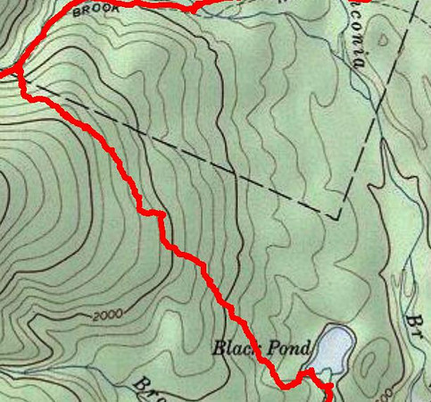
There were several cars in the Lincoln Woods parking lot, but no people. It was overcast, and warm. I got right on the trail and did a quick warm up to the Black Pond Trail. The Lincoln Woods Trail was wet, and the mud pits were plentiful. I sort of zigzagged my way through, staying mostly dry. The dry ended on the Black Pond Trail. It’s narrow footway and the undergrowth was wet and in no time I was soaked. After a quick stop for a snack and some pictures at Black Pond, I set my compass bearing.
This was my first solo bushwhack, well, planned bushwhack. I’ve had a few unplanned off trail adventures, but we all have, haven’t we? I went up the hill to the left of Black Pond to bypass some of the mud holes, then followed the bearing of 335, as suggested by BIGEarl and DaveBear. This route eventually brought me to an elevation of about 2000 feet, give or take a hundred feet or so. I went through fairly open woods, but there were a few hidden mud holes. In one, I sank to about mid-calf and hoped dearly that when I pulled my leg out that my boot was still attached. DaveBear described a large boulder to me, and I think I found it, maybe halfway through the ‘whack. The bushwhack took longer than I expected. I stopped a little to frequently to check my compass. I should have trusted the route, and my own instinct that I was more or less on bearing. I’ll know better next time. Shortly after passing the BearCave, I was on the big downhill toward the Lincoln Brook Trail.
I think the bushwhack ended between a half and three-quarters of a mile before the Liberty Brook crossing. I got to the crossing, and while not difficult, the water was high enough to make things interesting. The Lincoln Brook crossing was a little easier, but not much. Most of the good stepping stones were under water. Before long, I was at the junction with the Owl’s Head slide.
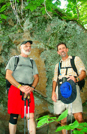
It was hard to miss the junction. I had a vague idea of what the area looked like, some hazy memory from my last trip there about two years ago. There are several items marking the junction now. I took a break, filtered some water and started up the slide. It was steeper than I remember. It was also a lot longer than I recall. The lower section is very loose. A few times I slid backward about as far as I had stepped forward. I wandered back and forth on the slide, looking for the best route. Eventually, the path entered the woods. The footing improved, but it was still steep. Finally I reached the ridge and after a few minutes I was on the traditional summit. There is not much on the old summit, just the old markings on a tree. I’m sure there are some other markings, but the USFS will have to find out on their own. The herd path to the new summit is pretty well defined. I saw several paths, but followed the one that looked the most used. After seeing no one all day, I saw Jack at the new summit. I don’t know how long he’s been there but he looked good. After a snack, I turned around and began the walk out. Past the old summit and across the ridge. I reached the approximate location to begin the Brutus bushwhack and after some deliberation, I opted to go down the slide. The Black Pond bushwhack was wet and muddy, and I guessed that Brutus would be more of the same. It took roughly an hour to get from the summit to the Lincoln Brook Trail. The physical challenge was over, now the mental challenge began. Eight miles to go. There is only one way out, walk. And keep walking, don’t think about the mileage. Nearing the end of a long day is a difficult time to stay motivated, and being solo makes it more so.
I got past the stream crossings again. Just after Liberty Brook I ran into three backpackers. They were going to go to Owl’s head, then to 13 Falls. Great day and night for a backpack. It took about another hour from the Slide junction to get to the point where my earlier bushwhack ended. Soon enough I was at the crossing of Lincoln Brook. About three hops into it, I went into it. That made things easier, I just waded across. Problem solved! At the next crossing I didn’t even bother to rock hop, I just walked in and across. Keep on keeping on, reaching the junction with the Franconia Brook Trail. 1.7 miles on this trail - can I get it done in an hour? Man…I hope so! I got a little muddy here, slipping off a stone and into a mud pit…oops.
At long last, I reached the Wilderness/Lincoln Woods Trail. 2.9 miles to go….another hour? The long, straight, no view, nothing to look at, probably gonna trip on a railroad tie and land flat on my face, and no one to tell bad jokes to section. C’mon, I’m tired! I set a lap using the stopwatch function on my watch to see how long the 2.9 (ugh!) miles would take. I dug deep and picked up the pace. There were a few people on this section, looking at the sweaty muddy guy power walking down the trail. I might have been talking to myself at this point….which explains people moving out of my way the way they did. There it is, the ten minute bridge. A quick left, then the suspension bridge. This one’s in the bag! 53 minutes, 5 seconds - do you think I wanted to get off that section of trail?
Yeah, the day was a challenge. From getting up early and the long ride to the Black Pond bushwhack. I found the bushwhack to be a lot like life. Keep going forward, if something gets in the way, go around it, go over it, go under it and sometimes, just blast right through it. The slide presented it’s own challenges, it is so relentlessly steep. Digging deep to keep going. It was just as challenging to go down the slide. But it got done, as did the entire hike, just another day in the life. I wouldn’t trade any of it for anything….it has been and continues to be an unbelievable ride
http://www.facebook.com/album.php?aid=213412&id=523928481&l=be436392ee
! Much has happened with us since my last TR, some very bad, but ultimately, some very good. My family and I have been tested to the max, and I think we did pretty well. Personally, I found out more about myself in the past year than I ever have before. I’ve learned that it’s not about what happens in your world, but it is about how you handle it.That’s sort of how this hike came about. I wanted to return to Owl’s Head, but I could only go on Friday, 9/24. No one was available, so it was a solo day. Owl’s Head is a long day, both physically and mentally. I decided to go, and to just do the best I could. BIGEarl gave me some information on a few of the bushwhacks, thanks Earl.
There were several cars in the Lincoln Woods parking lot, but no people. It was overcast, and warm. I got right on the trail and did a quick warm up to the Black Pond Trail. The Lincoln Woods Trail was wet, and the mud pits were plentiful. I sort of zigzagged my way through, staying mostly dry. The dry ended on the Black Pond Trail. It’s narrow footway and the undergrowth was wet and in no time I was soaked. After a quick stop for a snack and some pictures at Black Pond, I set my compass bearing.
This was my first solo bushwhack, well, planned bushwhack. I’ve had a few unplanned off trail adventures, but we all have, haven’t we? I went up the hill to the left of Black Pond to bypass some of the mud holes, then followed the bearing of 335, as suggested by BIGEarl and DaveBear. This route eventually brought me to an elevation of about 2000 feet, give or take a hundred feet or so. I went through fairly open woods, but there were a few hidden mud holes. In one, I sank to about mid-calf and hoped dearly that when I pulled my leg out that my boot was still attached. DaveBear described a large boulder to me, and I think I found it, maybe halfway through the ‘whack. The bushwhack took longer than I expected. I stopped a little to frequently to check my compass. I should have trusted the route, and my own instinct that I was more or less on bearing. I’ll know better next time. Shortly after passing the BearCave, I was on the big downhill toward the Lincoln Brook Trail.
I think the bushwhack ended between a half and three-quarters of a mile before the Liberty Brook crossing. I got to the crossing, and while not difficult, the water was high enough to make things interesting. The Lincoln Brook crossing was a little easier, but not much. Most of the good stepping stones were under water. Before long, I was at the junction with the Owl’s Head slide.
It was hard to miss the junction. I had a vague idea of what the area looked like, some hazy memory from my last trip there about two years ago. There are several items marking the junction now. I took a break, filtered some water and started up the slide. It was steeper than I remember. It was also a lot longer than I recall. The lower section is very loose. A few times I slid backward about as far as I had stepped forward. I wandered back and forth on the slide, looking for the best route. Eventually, the path entered the woods. The footing improved, but it was still steep. Finally I reached the ridge and after a few minutes I was on the traditional summit. There is not much on the old summit, just the old markings on a tree. I’m sure there are some other markings, but the USFS will have to find out on their own. The herd path to the new summit is pretty well defined. I saw several paths, but followed the one that looked the most used. After seeing no one all day, I saw Jack at the new summit. I don’t know how long he’s been there but he looked good. After a snack, I turned around and began the walk out. Past the old summit and across the ridge. I reached the approximate location to begin the Brutus bushwhack and after some deliberation, I opted to go down the slide. The Black Pond bushwhack was wet and muddy, and I guessed that Brutus would be more of the same. It took roughly an hour to get from the summit to the Lincoln Brook Trail. The physical challenge was over, now the mental challenge began. Eight miles to go. There is only one way out, walk. And keep walking, don’t think about the mileage. Nearing the end of a long day is a difficult time to stay motivated, and being solo makes it more so.
I got past the stream crossings again. Just after Liberty Brook I ran into three backpackers. They were going to go to Owl’s head, then to 13 Falls. Great day and night for a backpack. It took about another hour from the Slide junction to get to the point where my earlier bushwhack ended. Soon enough I was at the crossing of Lincoln Brook. About three hops into it, I went into it. That made things easier, I just waded across. Problem solved! At the next crossing I didn’t even bother to rock hop, I just walked in and across. Keep on keeping on, reaching the junction with the Franconia Brook Trail. 1.7 miles on this trail - can I get it done in an hour? Man…I hope so! I got a little muddy here, slipping off a stone and into a mud pit…oops.
At long last, I reached the Wilderness/Lincoln Woods Trail. 2.9 miles to go….another hour? The long, straight, no view, nothing to look at, probably gonna trip on a railroad tie and land flat on my face, and no one to tell bad jokes to section. C’mon, I’m tired! I set a lap using the stopwatch function on my watch to see how long the 2.9 (ugh!) miles would take. I dug deep and picked up the pace. There were a few people on this section, looking at the sweaty muddy guy power walking down the trail. I might have been talking to myself at this point….which explains people moving out of my way the way they did
. There it is, the ten minute bridge. A quick left, then the suspension bridge. This one’s in the bag! 53 minutes, 5 seconds - do you think I wanted to get off that section of trail?Yeah, the day was a challenge. From getting up early and the long ride to the Black Pond bushwhack. I found the bushwhack to be a lot like life. Keep going forward, if something gets in the way, go around it, go over it, go under it and sometimes, just blast right through it. The slide presented it’s own challenges, it is so relentlessly steep. Digging deep to keep going. It was just as challenging to go down the slide. But it got done, as did the entire hike, just another day in the life. I wouldn’t trade any of it for anything….it has been and continues to be an unbelievable ride
http://www.facebook.com/album.php?aid=213412&id=523928481&l=be436392ee
Last edited: